IMAGES TAKEN NEAR TO
Titchfield Road, CARSHALTON, SM5 1PX
Introduction
This page details the photographs taken nearby to Titchfield Road, SM5 1PX by members of the Geograph project.
The Geograph project started in 2005 with the aim of publishing, organising and preserving representative images for every square kilometre of Great Britain, Ireland and the Isle of Man.

There are currently over 7.5m images from over14,400 individuals and you can help contribute to the project by visiting https://www.geograph.org.uk
Image Map
Images are licensed for reuse under creativecommons.org/licenses/by-sa/2.0
Notes
- Clicking on the map will re-center to the selected point.
- The higher the marker number, the further away the image location is from the centre of the postcode.
Image Listing (15 Images Found)
Images are licensed for reuse under creativecommons.org/licenses/by-sa/2.0
Image
Details
Distance
1
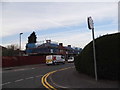
Welbeck Road at the corner of Thornton Road
Image: © David Howard
Taken: 24 Mar 2014
0.06 miles
2
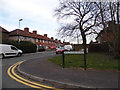
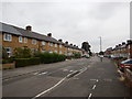
Waltham Road at the junction of Winchcombe Road
Image: © David Howard
Taken: 24 Mar 2014
0.13 miles
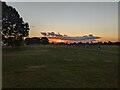
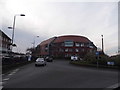
5
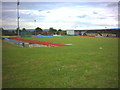
Sutton Arena and Leisure centre.
Off Middleton Road.
Image: © Noel Foster
Taken: 6 Jul 2005
0.21 miles
6
Wigmore Road
Kerb parking to help the flow of traffic.
Image: © James Emmans
Taken: 2 Sep 2016
0.21 miles

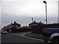
8
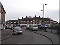
Shops on the Middleton Road roundabout
Image: © David Howard
Taken: 24 Mar 2014
0.23 miles
9
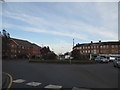
Roundabout on Middleton Road, St Helier
Image: © David Howard
Taken: 24 Mar 2014
0.23 miles
10
Flats on Middleton Road, St Helier
On the roundabout
Image: © David Howard
Taken: 24 Mar 2014
0.23 miles