IMAGES TAKEN NEAR TO
Shrewsbury Road, CARSHALTON, SM5 1LT
Introduction
This page details the photographs taken nearby to Shrewsbury Road, SM5 1LT by members of the Geograph project.
The Geograph project started in 2005 with the aim of publishing, organising and preserving representative images for every square kilometre of Great Britain, Ireland and the Isle of Man.

There are currently over 7.5m images from over14,400 individuals and you can help contribute to the project by visiting https://www.geograph.org.uk
Image Map
Images are licensed for reuse under creativecommons.org/licenses/by-sa/2.0
Notes
- Clicking on the map will re-center to the selected point.
- The higher the marker number, the further away the image location is from the centre of the postcode.
Image Listing (43 Images Found)
Images are licensed for reuse under creativecommons.org/licenses/by-sa/2.0
Image
Details
Distance
1
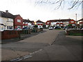
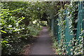
Buckhurst Avenue, Hackbridge
Buckhurst Avenue is a residential cul-de-sac in Hackbridge, in the outer suburbs of south London.
Image: © Malc McDonald
Taken: 4 Jan 2020
0.18 miles
2
Wandle Valley Health Centre, St Helier
Off Miller Close.
Image: © Stephen Richards
Taken: Unknown
0.18 miles
3
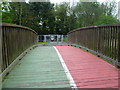
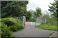
Footbridge across the Wandle near Watercress Park
Heading downriver, the Wandle Trail here switches from the east bank to the west bank. This view is of the footbridge carrying the path across the river, just after passing through Watercress Park.
Image: © Marathon
Taken: 2 May 2012
0.18 miles
4
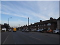
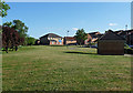
Middleton Road, St Helier
St Helier is mainly a huge council estate all with roughly similar houses like these.
Image: © David Howard
Taken: 24 Mar 2014
0.18 miles
5
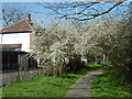
Footpath along River Wandle
The river is to the right, Buckhurst Avenue to the left.
Image: © Robin Webster
Taken: 28 Mar 2012
0.18 miles
8
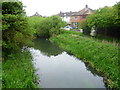
River Wandle from footbridge near Buckhurst Avenue
Heading downriver, the Wandle Trail here switches from the east bank to the west bank. This view looks back upriver. The houses are in Buckhurst Avenue.
Image: © Marathon
Taken: 2 May 2012
0.18 miles
9
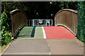
Bridge Over the River Wandle
Seen on the Wandle Trail, a cycling and walking route. The 20km (14 mile) Wandle Trail follows the route of the River Wandle from Croydon to the Thames at Wandsworth.
http://www.merton.gov.uk/leisure/visiting/attractions/wandletrail.htm
Image: © Peter Trimming
Taken: 5 Aug 2011
0.19 miles
10
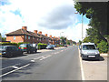
St. Helier: Middleton Road
Looking west.
Image: © Dr Neil Clifton
Taken: 28 Jul 2013
0.19 miles