IMAGES TAKEN NEAR TO
Wrythe Lane, CARSHALTON, SM5 1AA
Introduction
This page details the photographs taken nearby to Wrythe Lane, SM5 1AA by members of the Geograph project.
The Geograph project started in 2005 with the aim of publishing, organising and preserving representative images for every square kilometre of Great Britain, Ireland and the Isle of Man.

There are currently over 7.5m images from over14,400 individuals and you can help contribute to the project by visiting https://www.geograph.org.uk
Image Map
Images are licensed for reuse under creativecommons.org/licenses/by-sa/2.0
Notes
- Clicking on the map will re-center to the selected point.
- The higher the marker number, the further away the image location is from the centre of the postcode.
Image Listing (17 Images Found)
Images are licensed for reuse under creativecommons.org/licenses/by-sa/2.0
Image
Details
Distance
1
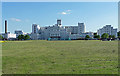
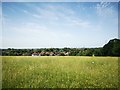
St Helier Hospital, Rosehill
Pevsner sums it up with "big, tall and broad ... in a utilitarian modern idiom". By Saxon Snell and Phillips in 1938. He omitted to mention its whiteness.
It is conspicuous in views from high points across south London, due to its bigness, tallness, whiteness, and the flat green expanse in front of it.
Image: © Stephen Richards
Taken: Unknown
0.02 miles
2
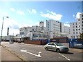
St. Helier Hospital
Serving a large area of South London
Image: © Dr Neil Clifton
Taken: 28 Jul 2013
0.03 miles
3
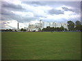
St Helier Hospital, Wrythe Lane, Sutton.
This large white building is visible on the skyline from quite large distances.
Image: © Noel Foster
Taken: 6 Jul 2005
0.04 miles
6
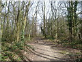
Path through Greenshaw Wood to St Helier Hospital
Greenshaw Wood lies within the public park known as Rosehill Park East. A strip of oak woodland formerly ran in a crescent from the site of the present St Helier Hospital south to a larger tract of woodland depicted on the First Edition Ordnance Survey Map as Been Hill. This strip of woodland was felled before 1815 and Been Hill became the new suburb of Benhilton. Greenshaw Wood is all that remains of these former ancient woods showing up with exactly the same boundaries as today on the Ordnance survey Map of 1866.
This view looks along a path near the southern boundary of Greenshaw Wood towards St Helier Hospital.
Image: © Marathon
Taken: 13 Mar 2013
0.13 miles
7
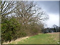
Greenshaw Wood
Greenshaw Wood lies within the public park known as Rosehill Park East. A strip of oak woodland formerly ran in a crescent from the site of the present St Helier Hospital south to a larger tract of woodland depicted on the First Edition Ordnance Survey Map as Been Hill. This strip of woodland was felled before 1815 and Been Hill became the new suburb of Benhilton. Greenshaw Wood is all that remains of these former ancient woods showing up with exactly the same boundaries as today on the Ordnance survey Map of 1866.
This view looks along the southern boundary of Greenshaw Wood.
Image: © Marathon
Taken: 13 Mar 2013
0.13 miles
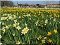
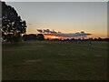
9
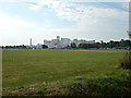
Open space in front of St Helier Hospital
This is an important photo for many people including the photographer.
The lighting was not ideal so I plan to get a better one in the future.
Wikipedia : https://en.wikipedia.org/wiki/St_Helier_Hospital
Image: © James Emmans
Taken: 25 Aug 2016
0.15 miles
10
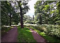
Footpath through Greenshaw Wood
Mature oak trees in woodland.
Image: © James Emmans
Taken: 21 Jun 2019
0.16 miles