IMAGES TAKEN NEAR TO
Middleton Road, MORDEN, SM4 6RR
Introduction
This page details the photographs taken nearby to Middleton Road, SM4 6RR by members of the Geograph project.
The Geograph project started in 2005 with the aim of publishing, organising and preserving representative images for every square kilometre of Great Britain, Ireland and the Isle of Man.

There are currently over 7.5m images from over14,400 individuals and you can help contribute to the project by visiting https://www.geograph.org.uk
Image Map
Images are licensed for reuse under creativecommons.org/licenses/by-sa/2.0
Notes
- Clicking on the map will re-center to the selected point.
- The higher the marker number, the further away the image location is from the centre of the postcode.
Image Listing (12 Images Found)
Images are licensed for reuse under creativecommons.org/licenses/by-sa/2.0
Image
Details
Distance
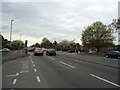
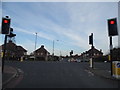
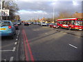
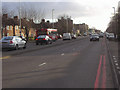
2
Junction of St Helier Avenue and Middleton Road
The bus on route 157 is bound for Crystal Palace via West Croydon, having started at Morden station.
Image: © Robin Webster
Taken: 1 Apr 2012
0.05 miles
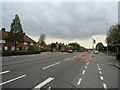
4
Middleton Road at the junction of St Helier Avenue
Image: © David Howard
Taken: 24 Mar 2014
0.05 miles
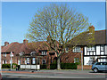
6
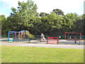
Moreton Green: Children's play area
Off Middleton Road
Image: © Dr Neil Clifton
Taken: 28 Jul 2013
0.09 miles
7
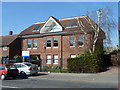
Meldrum House
This houses the Union of Shop, Distribution and Allied Workers.
Image: © Robin Webster
Taken: 1 Apr 2012
0.10 miles
8
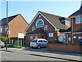
Schools Christian Resource Centre
Middleton Road, Morden.
Image: © Robin Webster
Taken: 1 Apr 2012
0.10 miles
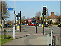
9
St Helier Avenue, Morden
Looking south towards the shopping centre.
Image: © David Howard
Taken: 26 Jan 2009
0.13 miles
10
Netley Gardens bus stop
On St. Helier Avenue, served by routes 157 and 164 southbound.
Image: © Robin Webster
Taken: 1 Apr 2012
0.14 miles