IMAGES TAKEN NEAR TO
Garendon Road, MORDEN, SM4 6NE
Introduction
This page details the photographs taken nearby to Garendon Road, SM4 6NE by members of the Geograph project.
The Geograph project started in 2005 with the aim of publishing, organising and preserving representative images for every square kilometre of Great Britain, Ireland and the Isle of Man.

There are currently over 7.5m images from over14,400 individuals and you can help contribute to the project by visiting https://www.geograph.org.uk
Image Map
Images are licensed for reuse under creativecommons.org/licenses/by-sa/2.0
Notes
- Clicking on the map will re-center to the selected point.
- The higher the marker number, the further away the image location is from the centre of the postcode.
Image Listing (20 Images Found)
Images are licensed for reuse under creativecommons.org/licenses/by-sa/2.0
Image
Details
Distance
2
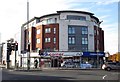
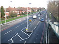
A217 Reigate Road
Heading towards London and towards the Rose Hill roundabout.
Image: © Robin Webster
Taken: 1 Apr 2012
0.12 miles
3
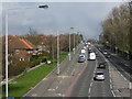
Reigate Avenue from a footbridge
Reigate Avenue is the A217 which by-passes the centre of Sutton. This view is from a footbridge near Glastonbury Road looking uphill towards Rosehill Roundabout with Rosehill Park West on the right.
Image: © Marathon
Taken: 13 Mar 2013
0.13 miles
4
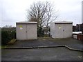
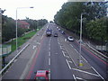
A217 Reigate Avenue (2)
Looking from Image towards St Helier with two northbound lanes and one southbound, the speed camera appears to have been torched.
Image: © Nigel Cox
Taken: 30 Jan 2008
0.13 miles
5
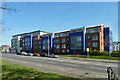
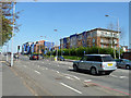
Flats, Rose Hill
There is another block of similar design to the right out of view, also fronting the A217 Reigate Road.
Image: © Robin Webster
Taken: 1 Apr 2012
0.14 miles
6
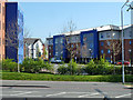
Flats, Rose Hill
One of several blocks of similar design here.
Image: © Robin Webster
Taken: 1 Apr 2012
0.14 miles
7
Reigate Avenue, Sutton
Taken from footbridge
Image: © David Howard
Taken: 1 Sep 2008
0.16 miles
8
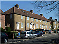
39 - 49 (odds) Garendon Road
Several blocks of similar design are along the road, but not all of six houses.
Image: © Robin Webster
Taken: 1 Apr 2012
0.16 miles
9

Morden: Hexham Road, St Helier Estate
Hexham Road is on the large St Helier Estate, built between 1928 and 1936 by the then London County Council (LCC), on land formerly owned by Westminster Abbey, for the re-housing of people from run-down inner London areas. The estate was named in honour of Lady St Helier, who was an LCC Alderman from 1910 to 1927. To commemorate the area's historic ownership, the roads are named in alphabetical order after Monasteries and Abbeys starting in the north-west with Aberconway Road and ending with Woburn Road in the south-east. All the road names on this particular area of the estate begin with the letters G (Garendon and Glastonbury) or H (Halesowen, Hartland, Hexham, and Hunston) or I (Iona) or K (Keynsham and Kirksted).
Image: © Nigel Cox
Taken: 30 Jan 2008
0.16 miles