IMAGES TAKEN NEAR TO
The Drive, MORDEN, SM4 6DP
Introduction
This page details the photographs taken nearby to The Drive, SM4 6DP by members of the Geograph project.
The Geograph project started in 2005 with the aim of publishing, organising and preserving representative images for every square kilometre of Great Britain, Ireland and the Isle of Man.

There are currently over 7.5m images from over14,400 individuals and you can help contribute to the project by visiting https://www.geograph.org.uk
Image Map
Images are licensed for reuse under creativecommons.org/licenses/by-sa/2.0
Notes
- Clicking on the map will re-center to the selected point.
- The higher the marker number, the further away the image location is from the centre of the postcode.
Image Listing (16 Images Found)
Images are licensed for reuse under creativecommons.org/licenses/by-sa/2.0
Image
Details
Distance
1
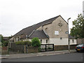
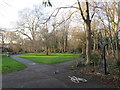
The Wyvern Youth Centre, Arras Avenue
This youth centre had originally been the hall of the adjacent St Francis Church. The church closed in 1962 and was demolished but the hall survived. It was part of the "Twenty Five churches" inter-war building campaign of Southwark Diocese, and more details of its history can be found in Richardson's book on the subject.
Image: © Stephen Craven
Taken: 26 Aug 2008
0.17 miles
3
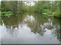
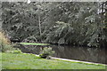
River Wandle in Ravensbury Park
Ravensbury Park was at one time part of the Ravensbury Estate. The estate was eventually broken up in 1929 and much was developed for housing, except for the present Ravensbury Park. This was bought jointly by Mitcham Council and Merton & Morden Council for £5,310. It was opened to the public in May 1930. The Wandle and its branches are the main feature of the park. This is the main channel of the Wandle looking downriver from a footbridge.
Image: © Marathon
Taken: 2 May 2012
0.21 miles
5
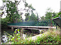
Footbridge across the Wandle
A substantial footbridge in Ravensbury Park.
Image: © Stephen Craven
Taken: 29 Aug 2011
0.22 miles
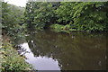
8
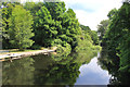
River Wandle in Ravensbury Park
The river has been artificially widened here as part of the landscaping of the former country estate of Ravensbury Park. Most of the estate was sold off for building in the 1930s but a part of it was kept and is now a municipal park.
Image: © Des Blenkinsopp
Taken: 9 Jul 2018
0.23 miles
9
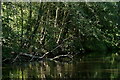
River Wandle
Looking downstream from Ravensbury Park.
Image: © Peter Trimming
Taken: 4 Sep 2023
0.23 miles
10
Squirrel on the path, near Mitcham
A grey squirrel scampering on a path near Mitcham.
The path forms part of the Wandle Trail, and is also on the route of National Cycle Network route 20. A National Cycle Network Millennium signpost stands to the right of the image.
This image was taken during an afternoon in early January. Trees were bare, the sun was low in the sky and shadows were long.
Image: © Malc McDonald
Taken: 4 Jan 2020
0.23 miles