IMAGES TAKEN NEAR TO
Matlock Crescent, SUTTON, SM3 9SN
Introduction
This page details the photographs taken nearby to Matlock Crescent, SM3 9SN by members of the Geograph project.
The Geograph project started in 2005 with the aim of publishing, organising and preserving representative images for every square kilometre of Great Britain, Ireland and the Isle of Man.

There are currently over 7.5m images from over14,400 individuals and you can help contribute to the project by visiting https://www.geograph.org.uk
Image Map
Images are licensed for reuse under creativecommons.org/licenses/by-sa/2.0
Notes
- Clicking on the map will re-center to the selected point.
- The higher the marker number, the further away the image location is from the centre of the postcode.
Image Listing (16 Images Found)
Images are licensed for reuse under creativecommons.org/licenses/by-sa/2.0
Image
Details
Distance
6
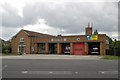
Sutton fire station
Sutton fire station, St Dunstans Hill, Sutton - part of the London Fire Brigade
Image: © Kevin Hale
Taken: 17 Jun 2007
0.15 miles
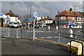
10
Windsor Avenue, North Cheam
This looks exactly the same as all the roads in Middlesex built around the same time and probably by the same builders,
Image: © David Howard
Taken: 29 Nov 2015
0.20 miles