IMAGES TAKEN NEAR TO
Henley Avenue, SUTTON, SM3 9SE
Introduction
This page details the photographs taken nearby to Henley Avenue, SM3 9SE by members of the Geograph project.
The Geograph project started in 2005 with the aim of publishing, organising and preserving representative images for every square kilometre of Great Britain, Ireland and the Isle of Man.

There are currently over 7.5m images from over14,400 individuals and you can help contribute to the project by visiting https://www.geograph.org.uk
Image Map
Images are licensed for reuse under creativecommons.org/licenses/by-sa/2.0
Notes
- Clicking on the map will re-center to the selected point.
- The higher the marker number, the further away the image location is from the centre of the postcode.
Image Listing (28 Images Found)
Images are licensed for reuse under creativecommons.org/licenses/by-sa/2.0
Image
Details
Distance
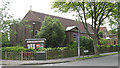
2
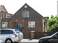
St Oswald's church, Molesey Drive
Suburban Anglican church, built 1953.
Image: © Stephen Craven
Taken: 8 Jun 2006
0.05 miles
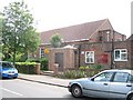
4
St Oswald's Church on Brock's Drive, North Cheam
Image: © David Howard
Taken: 29 Nov 2015
0.07 miles
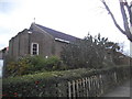
5
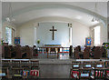
St Oswald, Brock's Drive, North Cheam - East end
Image: © John Salmon
Taken: 8 Jun 2005
0.07 miles
6
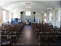
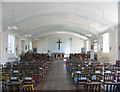
St Oswald, Brock's Drive, North Cheam - West end
Image: © John Salmon
Taken: 8 Jun 2005
0.07 miles
7
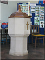
St Oswald, Brock's Drive, North Cheam - Font
Image: © John Salmon
Taken: 8 Jun 2005
0.07 miles
8
St Oswald (Old Church), Brock's Drive, North Cheam
Image: © John Salmon
Taken: 8 Jun 2005
0.07 miles
9
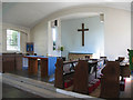
St Oswald, Brock's Drive, North Cheam - Chancel
Image: © John Salmon
Taken: 8 Jun 2005
0.07 miles
10
St Oswald, Brock's Drive, North Cheam - East end
Image: © John Salmon
Taken: 8 Jun 2005
0.08 miles