IMAGES TAKEN NEAR TO
Tilehurst Road, SUTTON, SM3 8PB
Introduction
This page details the photographs taken nearby to Tilehurst Road, SM3 8PB by members of the Geograph project.
The Geograph project started in 2005 with the aim of publishing, organising and preserving representative images for every square kilometre of Great Britain, Ireland and the Isle of Man.

There are currently over 7.5m images from over14,400 individuals and you can help contribute to the project by visiting https://www.geograph.org.uk
Image Map (Loading...)


Getting Data...Please wait
Leaflet Map data © OpenStreetMap
Images are licensed for reuse under creativecommons.org/licenses/by-sa/2.0
Notes
- Clicking on the map will re-center to the selected point.
- The higher the marker number, the further away the image location is from the centre of the postcode.
Image Listing (64 Images Found)
Images are licensed for reuse under creativecommons.org/licenses/by-sa/2.0
Image
Details
Distance

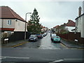
4

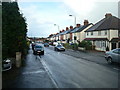
Older houses on Malden Road
Maps suggest these were built around Edwardian times.
Image: © Robin Webster
Taken: 10 Apr 2012
0.12 miles
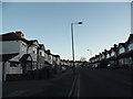
5
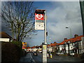
Tilehurst Road bus stop (northbound)
Served by routes 151, 213 and two school routes.
Image: © Robin Webster
Taken: 10 Apr 2012
0.12 miles

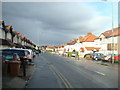
9
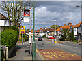
Malden Road, Cheam
This is a perfect example of the inter-war ribbon developments, some earlier, which line many of London's dual carriageways as well.
Image: © David Howard
Taken: 29 Dec 2013
0.19 miles