IMAGES TAKEN NEAR TO
Church Hill Road, SUTTON, SM3 8NE
Introduction
This page details the photographs taken nearby to Church Hill Road, SM3 8NE by members of the Geograph project.
The Geograph project started in 2005 with the aim of publishing, organising and preserving representative images for every square kilometre of Great Britain, Ireland and the Isle of Man.

There are currently over 7.5m images from over14,400 individuals and you can help contribute to the project by visiting https://www.geograph.org.uk
Image Map
Images are licensed for reuse under creativecommons.org/licenses/by-sa/2.0
Notes
- Clicking on the map will re-center to the selected point.
- The higher the marker number, the further away the image location is from the centre of the postcode.
Image Listing (26 Images Found)
Images are licensed for reuse under creativecommons.org/licenses/by-sa/2.0
Image
Details
Distance


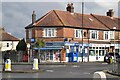
8
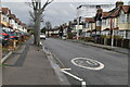
North Cheam: Priory Crescent
From its junction with Church Hill Road
Image: © Dr Neil Clifton
Taken: 26 Jul 2013
0.10 miles
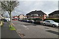
10

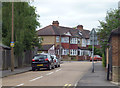
Windsor Avenue, Frogmore Gardens, Henley Avenue junction
Image: © N Chadwick
Taken: 17 Mar 2023
0.16 miles