IMAGES TAKEN NEAR TO
The Broadway, SUTTON, SM3 8BL
Introduction
This page details the photographs taken nearby to The Broadway, SM3 8BL by members of the Geograph project.
The Geograph project started in 2005 with the aim of publishing, organising and preserving representative images for every square kilometre of Great Britain, Ireland and the Isle of Man.

There are currently over 7.5m images from over14,400 individuals and you can help contribute to the project by visiting https://www.geograph.org.uk
Image Map
Images are licensed for reuse under creativecommons.org/licenses/by-sa/2.0
Notes
- Clicking on the map will re-center to the selected point.
- The higher the marker number, the further away the image location is from the centre of the postcode.
Image Listing (156 Images Found)
Images are licensed for reuse under creativecommons.org/licenses/by-sa/2.0
Image
Details
Distance
1
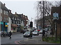
Cheam Village - The Broadway
Main street entering the village from the north.
http://en.wikipedia.org/wiki/Cheam
Image: © Colin Smith
Taken: 11 Mar 2013
0.06 miles
2
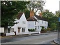
Weather-boarded cottages, Malden Road, Cheam
There are many local centres in London's Surrey suburbs - like Surbiton and Raynes Park - which owe their existence entirely to the coming of the railway. Cheam goes back much further, and is one of the relatively few places in the area where you get an impression of a village-scape from before the railway era. The most striking survival has got to be Whitehall, a timber-framed house dating from about 1500. But just north of it in the Malden Road stand these weather-boarded cottages.
The row of cottages further from the camera certainly looks pre-1850 (listing text: http://www.britishlistedbuildings.co.uk/en-206751-5-9-malden-road-greater-london-authority ) but the nearer building - known as Nonsuch Cottage - looks a good deal older, and the listing text confirms a 17th century date: http://www.britishlistedbuildings.co.uk/en-206749-nonsuch-cottage-greater-london-authority
Image: © Stefan Czapski
Taken: 13 Oct 2012
0.06 miles
3
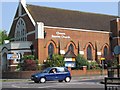
Cheam Baptist Church
Cheam Church is an outstanding large building dominating this corner of Cheam. With extensive halls and a large sanctuary.
Image: © Dave Eadie
Taken: 18 Aug 2005
0.06 miles
4
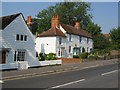
Cheam Period Cottages
Similar in style to the Whitehouse (Which space they sit next to) these period cottages are a reminder of the past Cheam Village once had.
Image: © Dave Eadie
Taken: 18 Aug 2005
0.06 miles
5
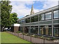
Cheam Library
Here is a lovely library in Cheam, behind which the Steeple of St Dunstans Church can be seen jutting.
Image: © Dave Eadie
Taken: 20 Aug 2005
0.06 miles
6
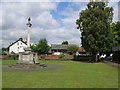
Cheam War Memorial
This is Cheam's war Memorial. Two the right of the picture is the library and St Dunstans. Two the left out of picture is Whitehall. A number of interesting geographic features all within such a small spot.
Image: © Dave Eadie
Taken: 20 Aug 2005
0.06 miles
8
Junction of Cheam Park Way and Park Lane
Image: © Basher Eyre
Taken: 15 Feb 2018
0.07 miles