IMAGES TAKEN NEAR TO
Turner Mews, SUTTON, SM2 6SX
Introduction
This page details the photographs taken nearby to Turner Mews, SM2 6SX by members of the Geograph project.
The Geograph project started in 2005 with the aim of publishing, organising and preserving representative images for every square kilometre of Great Britain, Ireland and the Isle of Man.

There are currently over 7.5m images from over14,400 individuals and you can help contribute to the project by visiting https://www.geograph.org.uk
Image Map
Images are licensed for reuse under creativecommons.org/licenses/by-sa/2.0
Notes
- Clicking on the map will re-center to the selected point.
- The higher the marker number, the further away the image location is from the centre of the postcode.
Image Listing (6 Images Found)
Images are licensed for reuse under creativecommons.org/licenses/by-sa/2.0
Image
Details
Distance
1
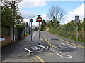
Railway bridge on Ventnor Road
Bridge NFE 1241 over the Epsom Downs to Norwood Junction line.
Image: © Robin Webster
Taken: 11 Apr 2012
0.17 miles
2
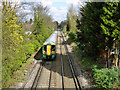
Train heading towards Sutton
Southern unit 377 449 is on the Epsom Downs to Norwood Junction line. It has just left the single line section which finishes just south of bridge NFE 1241 carrying Ventnor Road.
Image: © Robin Webster
Taken: 11 Apr 2012
0.17 miles
3
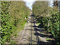
Epsom Downs to Norwood Junction line
The section between bridges NFE 1242 and NFE 1241, the distant bridge. Just before this the line becomes double track.
Image: © Robin Webster
Taken: 11 Apr 2012
0.18 miles
5
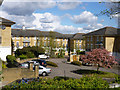
Housing on Kingswood Drive
Built in the grounds of the former Belmont Hospital.
Image: © Robin Webster
Taken: 11 Apr 2012
0.22 miles
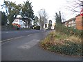
6
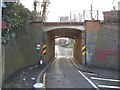
Narrow bridge on Grange Vale, Sutton
Now the pre-Worboys headroom sign has been revealed I will post the photo of it here as well.
Image: © David Howard
Taken: 4 Apr 2018
0.25 miles