IMAGES TAKEN NEAR TO
Bonchurch Close, SUTTON, SM2 6AZ
Introduction
This page details the photographs taken nearby to Bonchurch Close, SM2 6AZ by members of the Geograph project.
The Geograph project started in 2005 with the aim of publishing, organising and preserving representative images for every square kilometre of Great Britain, Ireland and the Isle of Man.

There are currently over 7.5m images from over14,400 individuals and you can help contribute to the project by visiting https://www.geograph.org.uk
Image Map
Images are licensed for reuse under creativecommons.org/licenses/by-sa/2.0
Notes
- Clicking on the map will re-center to the selected point.
- The higher the marker number, the further away the image location is from the centre of the postcode.
Image Listing (19 Images Found)
Images are licensed for reuse under creativecommons.org/licenses/by-sa/2.0
Image
Details
Distance
1
Fox leaving Eagle House
Well, it does say welcome!
Image: © Robin Webster
Taken: 11 Apr 2012
0.05 miles
2
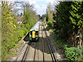
Train heading towards Sutton
Southern unit 377 449 is on the Epsom Downs to Norwood Junction line. It has just left the single line section which finishes just south of bridge NFE 1241 carrying Ventnor Road.
Image: © Robin Webster
Taken: 11 Apr 2012
0.10 miles
3
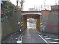
Railway bridge on Ventnor Road
Bridge NFE 1241 over the Epsom Downs to Norwood Junction line.
Image: © Robin Webster
Taken: 11 Apr 2012
0.13 miles
4
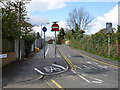
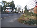
Narrow bridge on Grange Vale, Sutton
The island is a miracle of modern engineering, or possibly not.
Image: © David Howard
Taken: 4 Apr 2018
0.13 miles
5
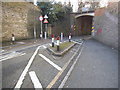
Narrow bridge on Grange Vale, Sutton
Now the pre-Worboys headroom sign has been revealed I will post the photo of it here as well.
Image: © David Howard
Taken: 4 Apr 2018
0.13 miles
6
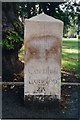
Old Milestone by the B2230, Brighton Road, Sutton
Carved stone post by the B2230 (was A217), in parish of SUTTON AND CHEAM (SUTTON District), Brighton Road, Larch Vale Court, on open grass, back from pavement, under tree, on West side of road. Surrey limestone pillar, erected by the Surrey & Sussex turnpike trust in the 18th century.
Inscription reads:-
XIII
Miles
From the
Standard
in
Cornhill
London
1745
J Parrot
Sutton 1882
Carved benchmark at base.
Scheduled Monument.
List Entry Number: 1002000 https://historicengland.org.uk/listing/the-list/list-entry/1002000
Milestone Society National ID: SY_LQR12.
Image: © L Joseph
Taken: 1 Mar 2005
0.13 miles
8
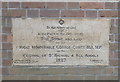
Christ Church, Christchurch Park, Sutton - Foundation stone
Image: © John Salmon
Taken: 1 Feb 2018
0.17 miles
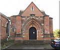
9
Christ Church, Christchurch Park, Sutton
Image: © John Salmon
Taken: 1 Feb 2018
0.18 miles
10
Christ Church, Christchurch Park, Sutton
Image: © John Salmon
Taken: 1 Feb 2018
0.18 miles