IMAGES TAKEN NEAR TO
Coniston Gardens, SUTTON, SM2 5EB
Introduction
This page details the photographs taken nearby to Coniston Gardens, SM2 5EB by members of the Geograph project.
The Geograph project started in 2005 with the aim of publishing, organising and preserving representative images for every square kilometre of Great Britain, Ireland and the Isle of Man.

There are currently over 7.5m images from over14,400 individuals and you can help contribute to the project by visiting https://www.geograph.org.uk
Image Map
Images are licensed for reuse under creativecommons.org/licenses/by-sa/2.0
Notes
- Clicking on the map will re-center to the selected point.
- The higher the marker number, the further away the image location is from the centre of the postcode.
Image Listing (7 Images Found)
Images are licensed for reuse under creativecommons.org/licenses/by-sa/2.0
Image
Details
Distance
1
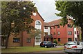
Rachael Court, Albion Road, Sutton, London
A three-storey block of flats dating from 1985 in the quiet leafy suburbs of Sutton.
Image: © Bob Embleton
Taken: 22 May 2014
0.13 miles
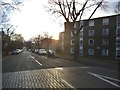
2
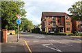
Cavendish Road / Langley Park Road junction, Sutton
Traffic calming raised road surface with a mini roundabout.
Most of the older victorian properties have been converted into flats or have been demolished and replaced by higher density flats.
Image: © Bob Embleton
Taken: 22 May 2014
0.13 miles
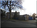
5
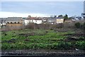
Wasteland between the lines, Sutton Junction
Image: © N Chadwick
Taken: 4 Feb 2018
0.21 miles
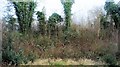
7
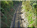
South Bermondsey Junction to Sutton line
Looking towards Sutton from bridge BTH1 1235 carrying King's Lane.
Image: © Robin Webster
Taken: 11 Apr 2012
0.25 miles