IMAGES TAKEN NEAR TO
Sutton Court Road, SUTTON, SM1 4SL
Introduction
This page details the photographs taken nearby to Sutton Court Road, SM1 4SL by members of the Geograph project.
The Geograph project started in 2005 with the aim of publishing, organising and preserving representative images for every square kilometre of Great Britain, Ireland and the Isle of Man.

There are currently over 7.5m images from over14,400 individuals and you can help contribute to the project by visiting https://www.geograph.org.uk
Image Map
Images are licensed for reuse under creativecommons.org/licenses/by-sa/2.0
Notes
- Clicking on the map will re-center to the selected point.
- The higher the marker number, the further away the image location is from the centre of the postcode.
Image Listing (83 Images Found)
Images are licensed for reuse under creativecommons.org/licenses/by-sa/2.0
Image
Details
Distance
1
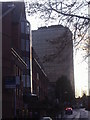
South Point, Sutton
Modern office block built in 1964.
Image: © David Howard
Taken: 23 Nov 2009
0.00 miles
2
Cycle permeability in Sutton
Sutton seems to be one of the better Outer London boroughs for cycle facilities. Here where Sutton Court Road crosses Langley Park Road there are point no-entries allowing cycle permeability, offering a relatively traffic-free route parallel to the main Carshalton Road.
Image: © Stephen Craven
Taken: 2 May 2015
0.02 miles
4
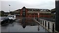
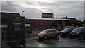
B&Q, Sutton: view south from car park
Image: © Christopher Hilton
Taken: 28 Jun 2013
0.02 miles
5
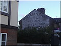
Old Ghost sign, Langley Park Road Sutton
The three digit telephone number dates this as extremely old despite its good condition.
Image: © David Howard
Taken: 23 Nov 2009
0.05 miles
6
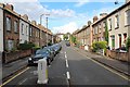
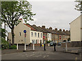
Morland Road, Sutton
Victorian terraced housing close to and running parallel to the railway line.
Image: © Bob Embleton
Taken: 22 May 2014
0.06 miles
8
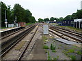
View eastwards from Sutton station
The lines diverge to the east of Sutton station, as they do to the west - see http://www.geograph.org.uk/photo/3013941 The right hand route was opened from West Croydon to Epsom on 10th May 1847 when Sutton station was also opened. The left hand route was opened on 1st October 1868 from Peckham Rye to Sutton via Mitcham Junction.
Image: © Marathon
Taken: 27 Jun 2012
0.08 miles
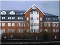
9
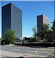
Vigilant House and Quadrant House, Sutton
Sutton has a cluster of tall-ish office blocks in this area, most of which seem to have been designed by Robert J. Wood and Partners, and most of which currently appear to be empty and/or awaiting redevelopment. Vigilant, in the foreground on Sutton Court Road, dates from 1961-66, and with its seventeen storeys of curtain-walling is very much of its time. To the right is the pink granite Quadrant House, of 1979-80, by Brewer, Smith and Brewer. It is occupied so neither of the above statements apply.
Image: © Stephen Richards
Taken: Unknown
0.08 miles
10
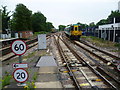
Two trains leaving Sutton station
The lines diverge to the east of Sutton station, as they do to the west - see http://www.geograph.org.uk/photo/3013941 The right hand route was opened from West Croydon to Epsom on 10th May 1847 when Sutton station was also opened. The left hand route was opened on 1st October 1868 from Peckham Rye to Sutton via Mitcham Junction. The next stop for the left hand train will be Carshalton, whilst the right hand train, although it is on the down line as it had terminated at Sutton, will next stop at Carshalton Beeches.
Image: © Marathon
Taken: 27 Jun 2012
0.09 miles