IMAGES TAKEN NEAR TO
Carshalton Road, SUTTON, SM1 4RA
Introduction
This page details the photographs taken nearby to Carshalton Road, SM1 4RA by members of the Geograph project.
The Geograph project started in 2005 with the aim of publishing, organising and preserving representative images for every square kilometre of Great Britain, Ireland and the Isle of Man.

There are currently over 7.5m images from over14,400 individuals and you can help contribute to the project by visiting https://www.geograph.org.uk
Image Map
Images are licensed for reuse under creativecommons.org/licenses/by-sa/2.0
Notes
- Clicking on the map will re-center to the selected point.
- The higher the marker number, the further away the image location is from the centre of the postcode.
Image Listing (156 Images Found)
Images are licensed for reuse under creativecommons.org/licenses/by-sa/2.0
Image
Details
Distance
1
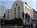
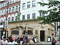
A building with interesting paintings on the side wall
The building is part of a parade of shops close to a pedestrian shopping centre
Image: © Jean Barrow
Taken: 15 Sep 2006
0.00 miles
3
Sutton High Street
High Street, Sutton, looking north across Cheam Road.
Image: © Malc McDonald
Taken: 28 Aug 2010
0.01 miles
4
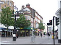
Sutton High Street
High Street, Sutton, looking south from the junction of Cheam Road. Note the direction signs attached to the pub sign.
Image: © Malc McDonald
Taken: 28 Aug 2010
0.02 miles
5
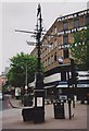
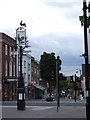
Old Direction Sign - Signpost on Sutton High Street by the A232
Pub sign finial - 4 arms; Surrey ornate by the A232, in parish of Sutton and Cheam (Sutton District), on a pedestrianised area of Sutton High Street south of the A232 Charshalton Road.
The sign has been refurbished and the direction arms removed between May 2019 and October 2020, possibly awaiting separate refurbishment.
Grade II listed.
List Entry Number: 145026 https://historicengland.org.uk/listing/the-list/list-entry/1450261
Surveyed
Milestone Society National ID: SY_TQ2564
Image: © Milestone Society
Taken: 8 May 2010
0.02 miles
6
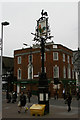
Junction sign, Sutton
The pre-Worboys direction pointers on this pub sign no longer serve a function: east-west traffic between Cheam and Carshalton whistles past on a one-way system, whilst the north-south axis towards Banstead or Mitcham is now pedestrianized.
Image: © Christopher Hilton
Taken: 17 Apr 2014
0.03 miles
7
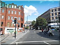
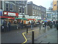
Pedestrian crossing on Cheam Road. Sutton
This is where the High Street crosses, which was pedestrianised around 25 years ago.
Image: © David Howard
Taken: 3 Aug 2014
0.03 miles
8
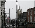
Sutton on a snowy Easter morning
Taken at the historic centre of Sutton, where London-Brighton and Croydon-Kingston roads crossed. The former is now the pedestrianised High Street. The sign above the signpost is that of the Cock Tavern, successor to the Cock Hotel, the main coaching inn of the town. In the background is Trinity Methodist Church, one of the three main town-centre churches, celebrating its centenary this year (2008).
Image: © Colin Bell
Taken: 23 Mar 2008
0.03 miles
9
The Cock and Bull Public House, Sutton
Image: © Stacey Harris
Taken: 3 Jun 2009
0.03 miles
10
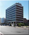
Watermead House, Sutton
Sutton has a cluster of tall-ish office blocks in this area, most of which seem to have been designed by Robert J. Wood and Partners, and most of which currently appear to be empty and/or awaiting redevelopment. This block, on Sutton Court Road, dates from 1975, and is faced with unbonded white tiles.
Image: © Stephen Richards
Taken: Unknown
0.03 miles