1
Sutton - Waterworks
These huge water reservoirs were located just north of the Carshalton Road (A232) to the east of Sutton. They were built in 1906 as part of the water-softening plant and were demolished in the 1980s for large-scale building development.
Image: © Brendan and Ruth McCartney
Taken: Unknown
0.05 miles
2
Old Ghost sign, Langley Park Road Sutton
The three digit telephone number dates this as extremely old despite its good condition.
Image: © David Howard
Taken: 23 Nov 2009
0.08 miles
3
The Nightingale, Carshalton Road
A Victorian pub on the corner of Carshalton and Lind Roads.
That second road is a clue to the pub's current name.
Jenny Lind was a famous mid 19th century singer known as "The Swedish Nightingale."
She was one of the earliest Celebrities in the modern sense, to the extent that there were pubs named after her, including, at one time, this one.
It's now called The Nightingale, so the connection is still there.
https://www.thenightingalesutton.co.uk/history
Image: © Des Blenkinsopp
Taken: 7 Oct 2024
0.09 miles
4
The Nightingale
A Casque Mark pub on Carshalton Road, Sutton.
Image: © Stephen Craven
Taken: 2 May 2015
0.10 miles
5
B&Q, Sutton: view south from car park
Image: © Christopher Hilton
Taken: 28 Jun 2013
0.10 miles
6
Cycle permeability in Sutton
Sutton seems to be one of the better Outer London boroughs for cycle facilities. Here where Sutton Court Road crosses Langley Park Road there are point no-entries allowing cycle permeability, offering a relatively traffic-free route parallel to the main Carshalton Road.
Image: © Stephen Craven
Taken: 2 May 2015
0.11 miles
7
Morland Road, Sutton
Victorian terraced housing close to and running parallel to the railway line.
Image: © Bob Embleton
Taken: 22 May 2014
0.11 miles
8
B&Q, Sutton
Image: © Christopher Hilton
Taken: 28 Jun 2013
0.11 miles
9
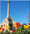
Sutton War Memorial, Manor Park, Sutton
Manor Park is also the site of the Sutton War Memorial. In 1921 the War Memorial Committee bought two houses adjacent to the park, and erected the war memorial in their place. Responsibility for maintaining the grounds of the memorial was taken on by the Council. The memorial was unveiled at a service in June 1921 by Sir Ralph Forster, a wealthy local resident whose son died in the war. It was designed by the architect JSW Burmester who lived in Grange Road, Sutton. The memorial, in Portland stone, consists of a large ornamental cross on a plinth.
524 men who died in the First World War are commemorated on the memorial. As well as the plaques containing names of the fallen, it has four panels, one containing an inscription, and the other three containing the emblems representing the Army, Navy and Royal Air Force. There are also four angels on the plinth overlooking the park. The inscription reads:
“This sign of the great sacrifice is raised in honour of OUR HEROIC DEAD, who gave their lives for England in the Great War. Their name liveth for evermore."
Image: © Tony Monblat
Taken: 18 Apr 2015
0.11 miles
10
South Point, Sutton
Modern office block built in 1964.
Image: © David Howard
Taken: 23 Nov 2009
0.12 miles


