IMAGES TAKEN NEAR TO
Brunswick Road, SUTTON, SM1 4DQ
Introduction
This page details the photographs taken nearby to Brunswick Road, SM1 4DQ by members of the Geograph project.
The Geograph project started in 2005 with the aim of publishing, organising and preserving representative images for every square kilometre of Great Britain, Ireland and the Isle of Man.

There are currently over 7.5m images from over14,400 individuals and you can help contribute to the project by visiting https://www.geograph.org.uk
Image Map
Images are licensed for reuse under creativecommons.org/licenses/by-sa/2.0
Notes
- Clicking on the map will re-center to the selected point.
- The higher the marker number, the further away the image location is from the centre of the postcode.
Image Listing (12 Images Found)
Images are licensed for reuse under creativecommons.org/licenses/by-sa/2.0
Image
Details
Distance
1
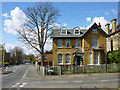
House on the corner
This is on Woodside Road where it meets Oakhill Road. It has at least three satellite dishes attached, so is presumably divided up into flats.
Image: © Robin Webster
Taken: 11 Apr 2012
0.12 miles
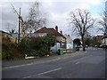
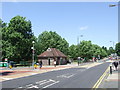
3
The Dolphin, Sutton
The pub has an air of being a pub no longer, although not boarded up and with hanging flower baskets. There are small red warning notices posted in the windows, but I did not cross the road to investigate.
Image: © Robin Webster
Taken: 11 Apr 2012
0.17 miles
4
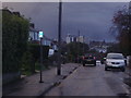
View of central Sutton from Woodside Road
Image: © David Howard
Taken: 14 Oct 2013
0.18 miles
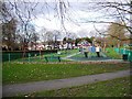
6
Sutton Green
Sutton Green, at the junction of Sutton High Street and Bushey Road.
Image: © Malc McDonald
Taken: 4 Jul 2010
0.21 miles
8

1960s terraces on Benhill Wood Road
This design was very popular in the 60s and possibly into the early 70s as well
Image: © David Howard
Taken: 14 Oct 2013
0.23 miles
9
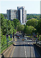
View down High Street, Sutton
Looking south from a footbridge. The dominant tower is the concrete Eagle Star House, of 1963-67, by the Owen Luder Partnership. There are shops at the bottom, and "wilfully complicated" stairs to a car park. Pevsner thinks the view is best from the north, "making an emphatic statement at the entrance to the High Street", but goes on, "closer up there are too many tricky details".
Image: © Stephen Richards
Taken: Unknown
0.24 miles
10
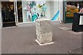
Milestone, Sutton High Street
Probably erected as part of the London to Brighton turnpike road built in 1755.
Now understood to be a scheduled ancient monument.
Whitehall XI Miles
Royal Exchange XII Miles
Image: © Bob Embleton
Taken: 23 May 2014
0.24 miles