IMAGES TAKEN NEAR TO
Nursery Road, SUTTON, SM1 4BP
Introduction
This page details the photographs taken nearby to Nursery Road, SM1 4BP by members of the Geograph project.
The Geograph project started in 2005 with the aim of publishing, organising and preserving representative images for every square kilometre of Great Britain, Ireland and the Isle of Man.

There are currently over 7.5m images from over14,400 individuals and you can help contribute to the project by visiting https://www.geograph.org.uk
Image Map
Images are licensed for reuse under creativecommons.org/licenses/by-sa/2.0
Notes
- Clicking on the map will re-center to the selected point.
- The higher the marker number, the further away the image location is from the centre of the postcode.
Image Listing (3 Images Found)
Images are licensed for reuse under creativecommons.org/licenses/by-sa/2.0
Image
Details
Distance
1
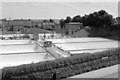
Sutton - Waterworks
These huge water reservoirs were located just north of the Carshalton Road (A232) to the east of Sutton. They were built in 1906 as part of the water-softening plant and were demolished in the 1980s for large-scale building development.
Image: © Brendan and Ruth McCartney
Taken: Unknown
0.22 miles
2
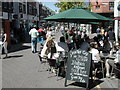
Saturday shopping in Sutton
Italian ice cream sold here... made with real Italians!
Image: © Peter Beaven
Taken: Unknown
0.22 miles