IMAGES TAKEN NEAR TO
Lenham Road, SUTTON, SM1 4AG
Introduction
This page details the photographs taken nearby to Lenham Road, SM1 4AG by members of the Geograph project.
The Geograph project started in 2005 with the aim of publishing, organising and preserving representative images for every square kilometre of Great Britain, Ireland and the Isle of Man.

There are currently over 7.5m images from over14,400 individuals and you can help contribute to the project by visiting https://www.geograph.org.uk
Image Map
Images are licensed for reuse under creativecommons.org/licenses/by-sa/2.0
Notes
- Clicking on the map will re-center to the selected point.
- The higher the marker number, the further away the image location is from the centre of the postcode.
Image Listing (101 Images Found)
Images are licensed for reuse under creativecommons.org/licenses/by-sa/2.0
Image
Details
Distance
1
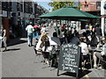
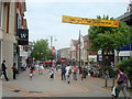
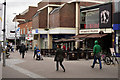
Saturday shopping in Sutton
Italian ice cream sold here... made with real Italians!
Image: © Peter Beaven
Taken: Unknown
0.11 miles
3
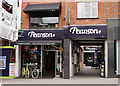
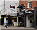
Pearson Cycles, Sutton
Dating from 1860, this is the oldest bike shop in the world. The shop is still run by the Pearson family.
Image: © Peter Trimming
Taken: 9 Jun 2015
0.12 miles
4
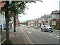
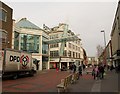
Sutton
Looking down the High Street, where several buildings are being re-built.
Image: © Peter Trimming
Taken: 9 Jun 2015
0.12 miles
5
Pearson Cycles, Sutton
Dating from 1860, this is the oldest bike shop in the world. The shop is still run by the Pearson family.
Image: © Peter Trimming
Taken: 9 Jun 2015
0.12 miles
6
Entrance to St Nicholas Centre, Sutton
The southern entrance to the pedestrianised High Street of the triple-floored shopping mall. The town's character appraisal comments that the "large buildings in these new developments interrupt the rhythm of the historic High Street and often introduce building materials and colours not in keeping with the older buildings" http://www.opinionsuite.com/sutton/highways-environment-and-planning/crossroads_consultation/supporting_documents/Draft%2520High%2520Street%2520Crossroads%2520Character%2520Appraisal.pdf&sa=U&ei=5eeATbbnBsqAhQebjomwBw&ved=0CBcQFjADOAo&sig2=8lw46Sn28imen48IJ-2lIA&usg=AFQjCNG6Am-Bz91MVyuhbV5VAhgyD8qVPg .
Image: © Derek Harper
Taken: 3 Feb 2011
0.13 miles
7
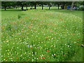
Wildflower meadow in Manor Park
Manor Park was formed from the grounds of three large suburban houses which stood along Carshalton Road, and a fourth in Manor Park Road. The latter, and largest, was called Manor Park House and gave its name to the park. In 1914, Sutton Urban District Council acquired Manor Park House and its grounds. The park was opened by the Chairman of the Urban District Council on 25th May, 1914.
This area of wild flowers is clearly very recently sown as it is so colourful. Wildflower meadows tend not to be quite so full of wild flowers after a few years.
Image: © Marathon
Taken: 27 Jun 2012
0.13 miles
8
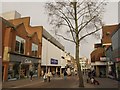
Sutton High Street
Shops on the long hill of the pedestrianised High Street. Image can be glimpsed further down, behind the tree.
Image: © Derek Harper
Taken: 3 Feb 2011
0.13 miles
9
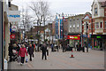
Sutton High Street
Looking along Sutton's pedestrianised High Street.
Image: © Stephen McKay
Taken: 17 Mar 2008
0.14 miles