IMAGES TAKEN NEAR TO
Benfleet Close, SUTTON, SM1 3SD
Introduction
This page details the photographs taken nearby to Benfleet Close, SM1 3SD by members of the Geograph project.
The Geograph project started in 2005 with the aim of publishing, organising and preserving representative images for every square kilometre of Great Britain, Ireland and the Isle of Man.

There are currently over 7.5m images from over14,400 individuals and you can help contribute to the project by visiting https://www.geograph.org.uk
Image Map
Images are licensed for reuse under creativecommons.org/licenses/by-sa/2.0
Notes
- Clicking on the map will re-center to the selected point.
- The higher the marker number, the further away the image location is from the centre of the postcode.
Image Listing (16 Images Found)
Images are licensed for reuse under creativecommons.org/licenses/by-sa/2.0
Image
Details
Distance

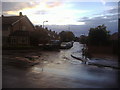
2
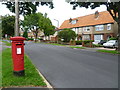
Benhill Road, Sutton
This pillar box is on the corner with Benfleet Close. Hillview Road can be seen in the distance.
Image: © Marathon
Taken: 27 Jun 2012
0.11 miles
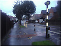
3

Mini roundabout at the junction of Benhill Road and Erskine Road
Image: © David Howard
Taken: 14 Oct 2013
0.11 miles
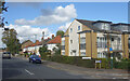
4

1960s terraces on Benhill Wood Road
This design was very popular in the 60s and possibly into the early 70s as well
Image: © David Howard
Taken: 14 Oct 2013
0.13 miles
6

Elgin Road at the junction of Benhill Road
Image: © David Howard
Taken: 14 Oct 2013
0.14 miles

8
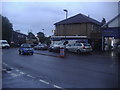
Oakhill Garage on Erskine Road, Benhilton
Image: © David Howard
Taken: 14 Oct 2013
0.18 miles
10
Chudleigh Gardens at the junction with Grennell Road
Image: © David Howard
Taken: 14 Oct 2013
0.20 miles