IMAGES TAKEN NEAR TO
Florian Avenue, SUTTON, SM1 3QH
Introduction
This page details the photographs taken nearby to Florian Avenue, SM1 3QH by members of the Geograph project.
The Geograph project started in 2005 with the aim of publishing, organising and preserving representative images for every square kilometre of Great Britain, Ireland and the Isle of Man.

There are currently over 7.5m images from over14,400 individuals and you can help contribute to the project by visiting https://www.geograph.org.uk
Image Map
Images are licensed for reuse under creativecommons.org/licenses/by-sa/2.0
Notes
- Clicking on the map will re-center to the selected point.
- The higher the marker number, the further away the image location is from the centre of the postcode.
Image Listing (14 Images Found)
Images are licensed for reuse under creativecommons.org/licenses/by-sa/2.0
Image
Details
Distance
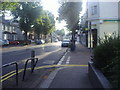
1
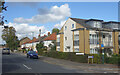
Oakhill Garage on Erskine Road, Benhilton
Image: © David Howard
Taken: 14 Oct 2013
0.06 miles
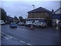
2
The Butterchurn pub and shops on Erskine Road
Image: © David Howard
Taken: 14 Oct 2013
0.08 miles
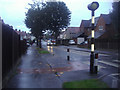
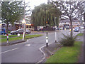
5

Mini roundabout at the junction of Benhill Road and Erskine Road
Image: © David Howard
Taken: 14 Oct 2013
0.13 miles
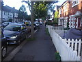
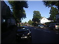
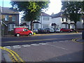
7
Westmead Road, Carshalton
Looking west from the junction with Byron Avenue
Image: © Dr Neil Clifton
Taken: 26 Sep 2007
0.16 miles
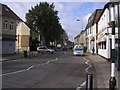
8
Junction of Cowper Avenue and Westmead Road
Image: © David Howard
Taken: 20 Aug 2011
0.18 miles