IMAGES TAKEN NEAR TO
Aultone Way, SUTTON, SM1 3LE
Introduction
This page details the photographs taken nearby to Aultone Way, SM1 3LE by members of the Geograph project.
The Geograph project started in 2005 with the aim of publishing, organising and preserving representative images for every square kilometre of Great Britain, Ireland and the Isle of Man.

There are currently over 7.5m images from over14,400 individuals and you can help contribute to the project by visiting https://www.geograph.org.uk
Image Map
Images are licensed for reuse under creativecommons.org/licenses/by-sa/2.0
Notes
- Clicking on the map will re-center to the selected point.
- The higher the marker number, the further away the image location is from the centre of the postcode.
Image Listing (16 Images Found)
Images are licensed for reuse under creativecommons.org/licenses/by-sa/2.0
Image
Details
Distance
2
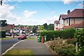
Rose Hill Park West
Steep road on the west side of Rose Hill. The Eastern side is a gentle slope going down to the River Wandle about 1.5 km away.
Image: © James Emmans
Taken: 21 Jun 2019
0.10 miles
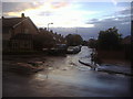
3
Edinburgh Road at the junction of Grennell Road
Image: © David Howard
Taken: 14 Oct 2013
0.17 miles
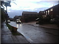
4
Grennell Road, Benhilton
One of the taller buildings of central Sutton is visible on the horizon.
Image: © Stephen Richards
Taken: Unknown
0.17 miles
6
Chudleigh Gardens at the junction with Grennell Road
Image: © David Howard
Taken: 14 Oct 2013
0.20 miles
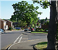
8
The edge of Greenshaw Wood
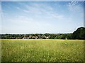
Greenshaw Wood lies within the public park known as Rosehill Park East. A strip of oak woodland formerly ran in a crescent from the site of the present St Helier Hospital south to a larger tract of woodland depicted on the First Edition Ordnance Survey Map as Been Hill. This strip of woodland was felled before 1815 and Been Hill became the new suburb of Benhilton. Greenshaw Wood is all that remains of these former ancient woods showing up with exactly the same boundaries as today on the Ordnance survey Map of 1866.
This view looks along the southern boundary of Greenshaw Wood downhill towards the houses in Rosehill Park West.
Image: © Marathon
Taken: 13 Mar 2013
0.22 miles
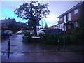
9
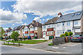
Duke of Edinburgh Road
Houses in Duke of Edinburgh Road, a road marked on the 1898 6 inch map and 1913 25 inch map (both simply as Edinburgh Road) only with a few houses at its northern end, beyond Prince of Wales Road. More houses are shown on the 1935 25 inch map (with the road named as currently), but the ones seen here are not marked until the 1944 6 inch map (in outline only), implying a mid - late 1930s building date.
Image: © Ian Capper
Taken: 25 Apr 2023
0.22 miles
10
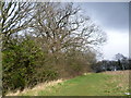
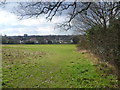
Greenshaw Wood
Greenshaw Wood lies within the public park known as Rosehill Park East. A strip of oak woodland formerly ran in a crescent from the site of the present St Helier Hospital south to a larger tract of woodland depicted on the First Edition Ordnance Survey Map as Been Hill. This strip of woodland was felled before 1815 and Been Hill became the new suburb of Benhilton. Greenshaw Wood is all that remains of these former ancient woods showing up with exactly the same boundaries as today on the Ordnance survey Map of 1866.
This view looks along the southern boundary of Greenshaw Wood.
Image: © Marathon
Taken: 13 Mar 2013
0.23 miles