IMAGES TAKEN NEAR TO
Fairlands Avenue, SUTTON, SM1 3JE
Introduction
This page details the photographs taken nearby to Fairlands Avenue, SM1 3JE by members of the Geograph project.
The Geograph project started in 2005 with the aim of publishing, organising and preserving representative images for every square kilometre of Great Britain, Ireland and the Isle of Man.

There are currently over 7.5m images from over14,400 individuals and you can help contribute to the project by visiting https://www.geograph.org.uk
Image Map
Images are licensed for reuse under creativecommons.org/licenses/by-sa/2.0
Notes
- Clicking on the map will re-center to the selected point.
- The higher the marker number, the further away the image location is from the centre of the postcode.
Image Listing (14 Images Found)
Images are licensed for reuse under creativecommons.org/licenses/by-sa/2.0
Image
Details
Distance
1
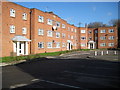
Sutton: Kedeston Court, Hurstcourt Road
The inscription in the stone tablet in the centre of the main façade of the block of flats reads:
S & C
1950
I am guessing therefore that these flats were originally built by the former Sutton & Cheam Council.
Image: © Nigel Cox
Taken: 30 Jan 2008
0.05 miles
2
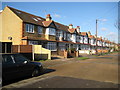
Sutton: Hurstcourt Road
Typical but attractive 1920s terraced houses with arched entranceways.
Image: © Nigel Cox
Taken: 30 Jan 2008
0.08 miles
5
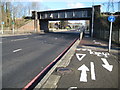
Sutton: A217 Reigate Avenue railway bridge
The bridge carries the railway line between Sutton Common and St Helier stations over the A217 here. The footbridge beyond is the one at Glastonbury Road. The white line marking crew have had a whale of a time here including a give way triangle at the tactile paving.
Image: © Nigel Cox
Taken: 30 Jan 2008
0.11 miles
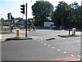
6
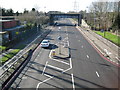
A217 Reigate Avenue (1)
This was taken from Image looking along the A217 Reigate Avenue with Image viewed from the opposite direction. The double red lines along both sides of the road indicate that this is a Red Route Urban Clearway where no stopping is allowed at any time, not only on the carriageway, but on the pavement and verge too.
Image: © Nigel Cox
Taken: 30 Jan 2008
0.11 miles
7
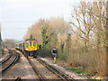
Train approaching Sutton Common
The train is formed of two 4-car class 319 "Thameslink" units and is on a service from Wimbledon to Luton (via Sutton and Blackfriars).
Image: © Stephen Craven
Taken: 3 Mar 2011
0.16 miles
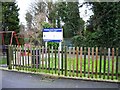
8
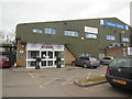
The Sports Village, Sutton
Multi Sport Venue in Sutton http://www.thesportsvillage.org.uk/
Image: © Paul Gillett
Taken: 20 Mar 2016
0.18 miles
9
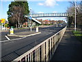
Sutton: A217 Glastonbury Road footbridge
The footbridge enables pedestrians to get from one side of the A217 Reigate Avenue to the other. The footbridge is marked on the OS 1:50,000 scale mapping, and Glastonbury Road is to the left.
(You should perhaps know that it is a London Borough of Sutton Byelaw that no person shall, without reasonable excuse,
(a) climb upon or hang from any bridge to which this byelaw applies; or
(b) aid, abet counsel or procure such an act by another.)
Image: © Nigel Cox
Taken: 30 Jan 2008
0.19 miles
10
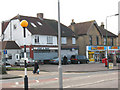
Shops on Sutton Common Road
The shops are nearly opposite the entrance to Sutton Common station. As at 2011 they consisted of a convenience store and a carpet showroom with one vacant unit between them.
Image: © Stephen Craven
Taken: 3 Mar 2011
0.20 miles