IMAGES TAKEN NEAR TO
Rosehill Avenue, SUTTON, SM1 3HG
Introduction
This page details the photographs taken nearby to Rosehill Avenue, SM1 3HG by members of the Geograph project.
The Geograph project started in 2005 with the aim of publishing, organising and preserving representative images for every square kilometre of Great Britain, Ireland and the Isle of Man.

There are currently over 7.5m images from over14,400 individuals and you can help contribute to the project by visiting https://www.geograph.org.uk
Image Map
Images are licensed for reuse under creativecommons.org/licenses/by-sa/2.0
Notes
- Clicking on the map will re-center to the selected point.
- The higher the marker number, the further away the image location is from the centre of the postcode.
Image Listing (29 Images Found)
Images are licensed for reuse under creativecommons.org/licenses/by-sa/2.0
Image
Details
Distance
1
Rose Hill, St Helier
Rose Hill, St Helier, photographed from the top deck of a 154 bus.
Image: © Malc McDonald
Taken: 4 Jul 2010
0.07 miles
2
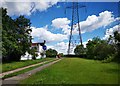
Path near St Helier Hospital Car park
Path through Rosehill Park for walkers and cyclists. National grid running overhead.
Image: © James Emmans
Taken: 21 Jun 2019
0.10 miles
3
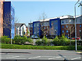
Flats, Rose Hill
One of several blocks of similar design here.
Image: © Robin Webster
Taken: 1 Apr 2012
0.11 miles
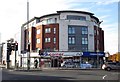
4
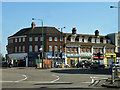
Corner shops, Rose Hill
On one of the corners of the six-way roundabout here. Most of the shops front Wrythe Lane.
Image: © Robin Webster
Taken: 1 Apr 2012
0.11 miles
6
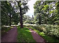
Footpath through Greenshaw Wood
Mature oak trees in woodland.
Image: © James Emmans
Taken: 21 Jun 2019
0.12 miles
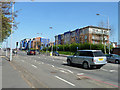
7
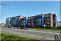
Flats, Rose Hill
There is another block of similar design to the right out of view, also fronting the A217 Reigate Road.
Image: © Robin Webster
Taken: 1 Apr 2012
0.12 miles
8
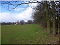
The western edge of Greenshaw Wood
Greenshaw Wood lies within the public park known as Rosehill Park East. A strip of oak woodland formerly ran in a crescent from the site of the present St Helier Hospital south to a larger tract of woodland depicted on the First Edition Ordnance Survey Map as Been Hill. This strip of woodland was felled before 1815 and Been Hill became the new suburb of Benhilton. Greenshaw Wood is all that remains of these former ancient woods showing up with exactly the same boundaries as today on the Ordnance survey Map of 1866.
This view looks along the western boundary of Greenshaw Wood towards the buildings around Rose Hill Roundabout.
Image: © Marathon
Taken: 13 Mar 2013
0.13 miles
9
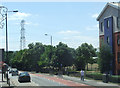
Rosehill roundabout.
A 6 way roundabout, crossed by A217 and B278 and termination of A297 and B2230. This picture from the north-east.
Image: © Noel Foster
Taken: 6 Jul 2005
0.14 miles
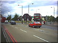
10
A217 Reigate Road
Heading towards London and towards the Rose Hill roundabout.
Image: © Robin Webster
Taken: 1 Apr 2012
0.14 miles