IMAGES TAKEN NEAR TO
Angel Hill, SUTTON, SM1 3EE
Introduction
This page details the photographs taken nearby to Angel Hill, SM1 3EE by members of the Geograph project.
The Geograph project started in 2005 with the aim of publishing, organising and preserving representative images for every square kilometre of Great Britain, Ireland and the Isle of Man.

There are currently over 7.5m images from over14,400 individuals and you can help contribute to the project by visiting https://www.geograph.org.uk
Image Map
Images are licensed for reuse under creativecommons.org/licenses/by-sa/2.0
Notes
- Clicking on the map will re-center to the selected point.
- The higher the marker number, the further away the image location is from the centre of the postcode.
Image Listing (47 Images Found)
Images are licensed for reuse under creativecommons.org/licenses/by-sa/2.0
Image
Details
Distance
1
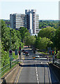
View down High Street, Sutton
Looking south from a footbridge. The dominant tower is the concrete Eagle Star House, of 1963-67, by the Owen Luder Partnership. There are shops at the bottom, and "wilfully complicated" stairs to a car park. Pevsner thinks the view is best from the north, "making an emphatic statement at the entrance to the High Street", but goes on, "closer up there are too many tricky details".
Image: © Stephen Richards
Taken: Unknown
0.04 miles
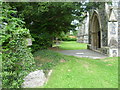
2
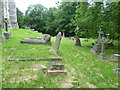
The churchyard of All Saints, Benhilton
All Saints is the church on the right as one heads northwards up the hill out of Sutton town centre. Large and prominently placed, All Saints dates from the 1860s.
Image: © Marathon
Taken: 27 Jun 2012
0.06 miles
3
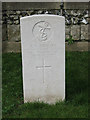
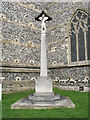
Commonwealth War Grave, Benhilton churchyard
There are two other such memorials in this churchyard listed on the NIWM website http://www.ukniwm.org.uk/ but this one (to seaman F.A.Munford) is not one of them.
Image: © Stephen Craven
Taken: 3 Mar 2011
0.07 miles
4
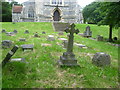
All Saints church, Benhilton: war memorial
A First World War memorial to the south of the church.
Details of inscriptions can be found on the NIWM website http://www.ukniwm.org.uk/ using Ref: 12540
Image: © Stephen Craven
Taken: 3 Mar 2011
0.07 miles
5
All Saints Church, Benhilton
All Saints is the church on the right as one heads northwards up the hill out of Sutton town centre. Large and prominently placed, All Saints dates from the 1860s.
Image: © Marathon
Taken: 27 Jun 2012
0.07 miles
6
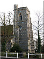
All Saints church, Benhilton: tower
The church tower seen from the green to the north of the church.
Image: © Stephen Craven
Taken: 3 Mar 2011
0.07 miles
7
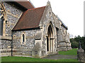
All Saints church, Benhilton: south porch
This porch is no longer used as an entrance to the church.
Image: © Stephen Craven
Taken: 3 Mar 2011
0.07 miles
8
The north doorway of All Saints Church, Benhilton
All Saints is the church on the right as one heads northwards up the hill out of Sutton town centre. Large and prominently placed, All Saints dates from the 1860s.
Image: © Marathon
Taken: 27 Jun 2012
0.08 miles
9
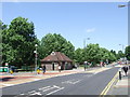
Sutton Green
Sutton Green, at the junction of Sutton High Street and Bushey Road.
Image: © Malc McDonald
Taken: 4 Jul 2010
0.08 miles