IMAGES TAKEN NEAR TO
Robin Hood Lane, SUTTON, SM1 2SE
Introduction
This page details the photographs taken nearby to Robin Hood Lane, SM1 2SE by members of the Geograph project.
The Geograph project started in 2005 with the aim of publishing, organising and preserving representative images for every square kilometre of Great Britain, Ireland and the Isle of Man.

There are currently over 7.5m images from over14,400 individuals and you can help contribute to the project by visiting https://www.geograph.org.uk
Image Map
Images are licensed for reuse under creativecommons.org/licenses/by-sa/2.0
Notes
- Clicking on the map will re-center to the selected point.
- The higher the marker number, the further away the image location is from the centre of the postcode.
Image Listing (37 Images Found)
Images are licensed for reuse under creativecommons.org/licenses/by-sa/2.0
Image
Details
Distance
2
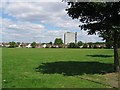
Collingwood Park, Sutton
This park is framed by housing all around. An allotment lies to the left of the picture and to the right is a railway track leading over the bridge over Collingwood Road and a football ground (Sutton United).
Image: © Dave Eadie
Taken: 7 Aug 2005
0.15 miles
3
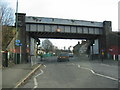
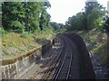
Collingwood Road Railway Bridge, Sutton
This is a heavy older railway bridge over a main road near the bottom half of Sutton. The track leads up towards West Sutton Station, to the right of the photo about half a mile away, the other way leads down to St Helier station also about half a mile away.
Image: © Dave Eadie
Taken: 14 Jan 2005
0.15 miles
5
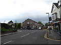
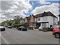
Looking from West Street towards Robin Hood Road
Image: © Basher Eyre
Taken: 24 Apr 2019
0.18 miles
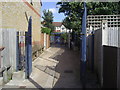
6
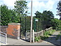
Footpath near West Sutton station
Footpath leading from Norman Road to St James's Road, Sutton.
Image: © Malc McDonald
Taken: 28 Aug 2010
0.18 miles
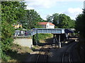
7
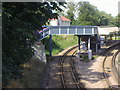
West Sutton station bridge and platform
Image: © David Howard
Taken: 1 Sep 2008
0.19 miles
9
West Sutton station
West Sutton station, seen from Norman Road.
Image: © Malc McDonald
Taken: 28 Aug 2010
0.20 miles
10
Entrance to West Sutton station
Gander Green Lane
Image: © David Howard
Taken: 1 Sep 2008
0.20 miles