IMAGES TAKEN NEAR TO
Cheam Road, SUTTON, SM1 2BT
Introduction
This page details the photographs taken nearby to Cheam Road, SM1 2BT by members of the Geograph project.
The Geograph project started in 2005 with the aim of publishing, organising and preserving representative images for every square kilometre of Great Britain, Ireland and the Isle of Man.

There are currently over 7.5m images from over14,400 individuals and you can help contribute to the project by visiting https://www.geograph.org.uk
Image Map
Images are licensed for reuse under creativecommons.org/licenses/by-sa/2.0
Notes
- Clicking on the map will re-center to the selected point.
- The higher the marker number, the further away the image location is from the centre of the postcode.
Image Listing (127 Images Found)
Images are licensed for reuse under creativecommons.org/licenses/by-sa/2.0
Image
Details
Distance
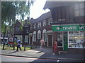
1
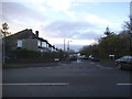
Cheam Road at the junction of Quarry Park Road
Image: © David Howard
Taken: 4 Apr 2018
0.03 miles
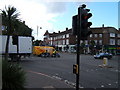
3
Cheam: eastward on Ewell Road, 1985
View on A232 towards Sutton.
Image: © Ben Brooksbank
Taken: 7 Jul 1985
0.19 miles
6

Cheam Library
Here is a lovely library in Cheam, behind which the Steeple of St Dunstans Church can be seen jutting.
Image: © Dave Eadie
Taken: 20 Aug 2005
0.19 miles
7
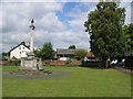
Cheam War Memorial
This is Cheam's war Memorial. Two the right of the picture is the library and St Dunstans. Two the left out of picture is Whitehall. A number of interesting geographic features all within such a small spot.
Image: © Dave Eadie
Taken: 20 Aug 2005
0.19 miles
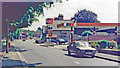
9
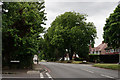
Cheam Road, Cheam
Looking in the direction of Cheam.
Image: © Peter Trimming
Taken: 9 Jun 2015
0.20 miles
10
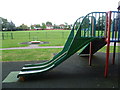
Playground in Seears Park
Seears Park is the formal area to the south of the woods of Perretts Field. The interest of the park is somewhat limited, apart from the fact it has a playground and a view of the woods.
In this view, the houses in the distance are in Quarry Park Road.
Image: © Marathon
Taken: 11 Sep 2013
0.20 miles