IMAGES TAKEN NEAR TO
St. Nicholas Way, SUTTON, SM1 1JN
Introduction
This page details the photographs taken nearby to St. Nicholas Way, SM1 1JN by members of the Geograph project.
The Geograph project started in 2005 with the aim of publishing, organising and preserving representative images for every square kilometre of Great Britain, Ireland and the Isle of Man.

There are currently over 7.5m images from over14,400 individuals and you can help contribute to the project by visiting https://www.geograph.org.uk
Image Map
Images are licensed for reuse under creativecommons.org/licenses/by-sa/2.0
Notes
- Clicking on the map will re-center to the selected point.
- The higher the marker number, the further away the image location is from the centre of the postcode.
Image Listing (33 Images Found)
Images are licensed for reuse under creativecommons.org/licenses/by-sa/2.0
Image
Details
Distance
1
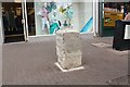
Milestone, Sutton High Street
Probably erected as part of the London to Brighton turnpike road built in 1755.
Now understood to be a scheduled ancient monument.
Whitehall XI Miles
Royal Exchange XII Miles
Image: © Bob Embleton
Taken: 23 May 2014
0.09 miles
2
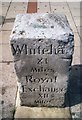
Old Milestone by the former B2230, Sutton High Street, Sutton and Cheam Parish
Carved stone post by the B2230 (was A217), in parish of SUTTON AND CHEAM (SUTTON District), Sutton High Street; by Sports Bar, in pavement slabs, beside cycle stands, on East side of road. Surrey limestone pillar, erected by the Surrey & Sussex turnpike trust in the 19th century.
Inscription reads:-
Whiteha(ll)
XI
Miles
Royal
Exchange
XII
Miles
Scheduled Monument. List Entry Number: 1001998
https://historicengland.org.uk/listing/the-list/list-entry/1001998
Milestone Society National ID: SY_LQR11a.
Image: © L Mead
Taken: 22 Aug 2002
0.09 miles
3
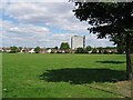
Collingwood Park, Sutton
This park is framed by housing all around. An allotment lies to the left of the picture and to the right is a railway track leading over the bridge over Collingwood Road and a football ground (Sutton United).
Image: © Dave Eadie
Taken: 7 Aug 2005
0.14 miles
4
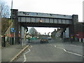
Collingwood Road Railway Bridge, Sutton
This is a heavy older railway bridge over a main road near the bottom half of Sutton. The track leads up towards West Sutton Station, to the right of the photo about half a mile away, the other way leads down to St Helier station also about half a mile away.
Image: © Dave Eadie
Taken: 14 Jan 2005
0.14 miles
5
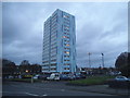
Tower block by Collingwood Road, Sutton
This has recently been clad in blue from bare concrete
Image: © David Howard
Taken: 29 Nov 2015
0.15 miles
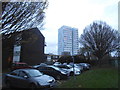
6
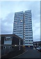
Tower block by Collingwood Road, Sutton
Image: © David Howard
Taken: 29 Nov 2015
0.16 miles
9
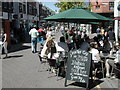
Saturday shopping in Sutton
Italian ice cream sold here... made with real Italians!
Image: © Peter Beaven
Taken: Unknown
0.17 miles
10
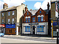
The Dolphin, Sutton
The pub has an air of being a pub no longer, although not boarded up and with hanging flower baskets. There are small red warning notices posted in the windows, but I did not cross the road to investigate.
Image: © Robin Webster
Taken: 11 Apr 2012
0.18 miles