IMAGES TAKEN NEAR TO
Grove Road, SUTTON, SM1 1BG
Introduction
This page details the photographs taken nearby to Grove Road, SM1 1BG by members of the Geograph project.
The Geograph project started in 2005 with the aim of publishing, organising and preserving representative images for every square kilometre of Great Britain, Ireland and the Isle of Man.

There are currently over 7.5m images from over14,400 individuals and you can help contribute to the project by visiting https://www.geograph.org.uk
Image Map
Images are licensed for reuse under creativecommons.org/licenses/by-sa/2.0
Notes
- Clicking on the map will re-center to the selected point.
- The higher the marker number, the further away the image location is from the centre of the postcode.
Image Listing (160 Images Found)
Images are licensed for reuse under creativecommons.org/licenses/by-sa/2.0
Image
Details
Distance
1
Grove Road, Sutton
As seen through a typically impressive display of 'street furniture'.
Image: © Stephen Richards
Taken: Unknown
0.01 miles
3
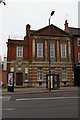
Masonic Hall, Grove Road, Sutton
Image: © Christopher Hilton
Taken: 17 Apr 2014
0.03 miles
4
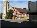
Cheam Road Hall, Sutton
In view of this small building's proximity to Trinity Church, I assume it i used for religious purposes.
Image: © Dr Neil Clifton
Taken: 15 Oct 2009
0.05 miles
5
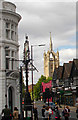
Sutton High St crossroads, SUTTON, Surrey, Greater London
Cheam Rd at its crossroads with Sutton High St - Trinity Church in distance.
Image: © Tony Monblat
Taken: 24 May 2016
0.06 miles
7
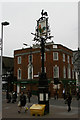
Junction sign, Sutton
The pre-Worboys direction pointers on this pub sign no longer serve a function: east-west traffic between Cheam and Carshalton whistles past on a one-way system, whilst the north-south axis towards Banstead or Mitcham is now pedestrianized.
Image: © Christopher Hilton
Taken: 17 Apr 2014
0.06 miles
8
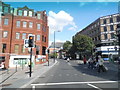
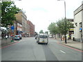
Pedestrian crossing on Cheam Road. Sutton
This is where the High Street crosses, which was pedestrianised around 25 years ago.
Image: © David Howard
Taken: 3 Aug 2014
0.06 miles
9
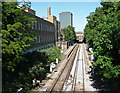
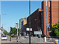
Sutton-Cheam railway (1)
Looking north-east with Sutton station just ahead. The building on the left is Royal Mail offices. The tower ahead is Vigilant House (1961-66, by Robert J. Wood and Partners).
Taken from the aptly-named Bridge Road.
Image: © Stephen Richards
Taken: Unknown
0.06 miles
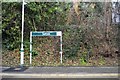
10
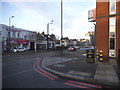
Grove Road at the corner of Bridge Road
Image: © David Howard
Taken: 4 Apr 2018
0.06 miles