IMAGES TAKEN NEAR TO
Woodhill Avenue, GERRARDS CROSS, SL9 8DP
Introduction
This page details the photographs taken nearby to Woodhill Avenue, SL9 8DP by members of the Geograph project.
The Geograph project started in 2005 with the aim of publishing, organising and preserving representative images for every square kilometre of Great Britain, Ireland and the Isle of Man.

There are currently over 7.5m images from over14,400 individuals and you can help contribute to the project by visiting https://www.geograph.org.uk
Image Map
Images are licensed for reuse under creativecommons.org/licenses/by-sa/2.0
Notes
- Clicking on the map will re-center to the selected point.
- The higher the marker number, the further away the image location is from the centre of the postcode.
Image Listing (19 Images Found)
Images are licensed for reuse under creativecommons.org/licenses/by-sa/2.0
Image
Details
Distance
1
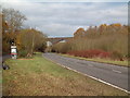
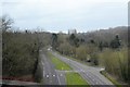
Viaduct over Misbourne Valley
This railway viaduct carries the Chiltern Line over both the A413 and the River Misbourne just east of Gerrards Cross. The same viaduct spans the M25 a few hundred metres east.
Image: © David Squire
Taken: 5 Dec 2005
0.01 miles
2
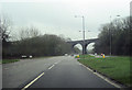
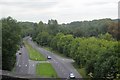
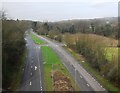
Railway Bridge over A413
Just east of Gerrards Cross Station
Image: © John Firth
Taken: 17 Mar 2012
0.04 miles
8
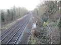
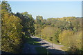
Gerrards Cross: Chiltern Railways main line
The line was a very late addition to the national railway network, only being completed in 1906 as a joint venture by the Great Western and Great Central Railways. This is the view from the side of the Mill Lane bridge over it, looking towards the viaduct crossings of the A413 and then the M25.
Image: © Nigel Cox
Taken: 22 Dec 2013
0.10 miles
9
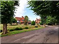
Woodhill Avenue
Large houses in a private road.
Image: © James Emmans
Taken: 7 Aug 2019
0.13 miles
10
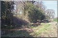
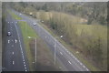
River Misbourne Isle of Wight Farm
This part of the River Misbourne was experiencing extreme low flows when this photograph was taken in the spring of 1997. The river here dried out for several months later that year, becoming dry from source downstream to the discharge point of Gerrards Cross sewage treatment works.
Native white-clawed crayfish (Austropotamobius pallipes) were regularly seen in the Misbourne here until the channel dried in 1997. A short reach of the Misbourne here was one of the last places they could still be found across the home counties - from where they are now almost certainly locally extinct.
The invasive North American signal crayfish (Pacifastacus leniusculus) is now abundant within the Misbourne, as elsewhere across much of southern England. The spread of this species has eradicated populations of native crayfish as they carry a lethal fungus and outcompete the smaller native species. Although signals first became established within Shardeloes Lake and the upper Misbourne during the early 1990s, the native crayfish population downstream was protected by the isolation caused by a lengthy intermediate section of river that remained perennially dry during this period.
Image: © David Leeming
Taken: 7 Apr 1997
0.13 miles