IMAGES TAKEN NEAR TO
Moreland Drive, GERRARDS CROSS, SL9 8BB
Introduction
This page details the photographs taken nearby to Moreland Drive, SL9 8BB by members of the Geograph project.
The Geograph project started in 2005 with the aim of publishing, organising and preserving representative images for every square kilometre of Great Britain, Ireland and the Isle of Man.

There are currently over 7.5m images from over14,400 individuals and you can help contribute to the project by visiting https://www.geograph.org.uk
Image Map
Images are licensed for reuse under creativecommons.org/licenses/by-sa/2.0
Notes
- Clicking on the map will re-center to the selected point.
- The higher the marker number, the further away the image location is from the centre of the postcode.
Image Listing (16 Images Found)
Images are licensed for reuse under creativecommons.org/licenses/by-sa/2.0
Image
Details
Distance
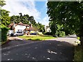
1
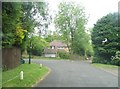
Hill Waye at the corner of Beech Waye
This is a private estate but open to visitors without any security measures
Image: © David Howard
Taken: 11 Jun 2013
0.12 miles
2
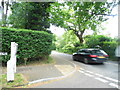
Mill Lane at the junction of Hill Waye
Image: © David Howard
Taken: 11 Jun 2013
0.15 miles
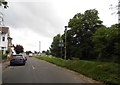
5
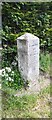
Milestone Oxford Road
On the northern verge. Alternative views see https://www.geograph.org.uk/photo/5622531 & https://www.geograph.org.uk/photo/6742369
Uxbridge / 4 // London / 19 / Oxford / 35 / Beaconsfield / 4
Milestone Society National ID: BU_LW19
Image: © Henry Allum
Taken: 24 Jul 2020
0.20 miles
6
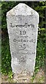
Milestone Oxford Road, Gerrards Cross
On the northern verge. Alternative views see https://www.geograph.org.uk/photo/5622531 & https://www.geograph.org.uk/photo/6742354
Uxbridge / 4 // London / 19 / Oxford / 35 / Beaconsfield / 4
Milestone Society National ID: BU_LW19
Image: © Henry Allum
Taken: 24 Jul 2020
0.20 miles
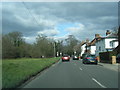
7
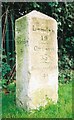
Old Milestone by the A40 in Gerrards Cross
Carved stone post by the A40, in parish of Gerrards Cross (South Bucks District), Oxford Road; by Woodhill, eastern edge of town, on lawn to left of gates to Woodhill, on North side of road. Beaconsfield diamond pillar, erected by the Red Hill & Beaconsfield turnpike trust in the 18th century.
Inscription reads:-
: Uxbridge / 4 : : London / 19 / - / Oxford / 35 / - / Beaconsfield / 4 :
Buckinghamshire HER.
HER Number: 1361200000 https://www.heritagegateway.org.uk/Gateway/Results_Single.aspx?uid=MBC25806&resourceID=1024
Milestone Society National ID: BU_LW19
Image: © A Rosevear
Taken: 25 Oct 2001
0.21 miles
9
Gerrards Cross - Beech Waye Private Road
Large detached houses.
Image: © James Emmans
Taken: 7 Aug 2019
0.22 miles
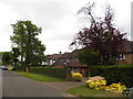
10
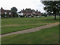
Gerrards Cross Common
South East corner of Gerrards Cross Common between East Common and Oxford Road
Image: © Shaun Ferguson
Taken: 7 Aug 2009
0.22 miles