IMAGES TAKEN NEAR TO
Birchdale, GERRARDS CROSS, SL9 7JA
Introduction
This page details the photographs taken nearby to Birchdale, SL9 7JA by members of the Geograph project.
The Geograph project started in 2005 with the aim of publishing, organising and preserving representative images for every square kilometre of Great Britain, Ireland and the Isle of Man.

There are currently over 7.5m images from over14,400 individuals and you can help contribute to the project by visiting https://www.geograph.org.uk
Image Map
Images are licensed for reuse under creativecommons.org/licenses/by-sa/2.0
Notes
- Clicking on the map will re-center to the selected point.
- The higher the marker number, the further away the image location is from the centre of the postcode.
Image Listing (7 Images Found)
Images are licensed for reuse under creativecommons.org/licenses/by-sa/2.0
Image
Details
Distance
3
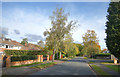
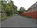
High Beeches at the junction of Howards Wood Drive
Image: © David Howard
Taken: 15 Jun 2017
0.16 miles
4
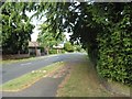
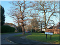
Houses on the corner of Howards Wood Drive
The houses are on Fulmer Drive
Image: © David Howard
Taken: 15 Jun 2017
0.17 miles
5
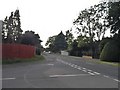
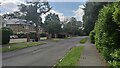
Howards Wood Drive, Gerrards Cross
The house on the right is fairly newly built
Image: © David Howard
Taken: 15 Jun 2017
0.18 miles
6
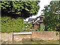
Corner of The Uplands and Dale Side
In a residential area of Gerrards Cross.
Image: © Robin Webster
Taken: 18 Jan 2015
0.19 miles
7
Fulmer Drive - Gerrard's Cross
Large detached houses to the south of the expensive commuter town.
Image: © James Emmans
Taken: 23 Jun 2021
0.22 miles