IMAGES TAKEN NEAR TO
Howards Wood Drive, GERRARDS CROSS, SL9 7HN
Introduction
This page details the photographs taken nearby to Howards Wood Drive, SL9 7HN by members of the Geograph project.
The Geograph project started in 2005 with the aim of publishing, organising and preserving representative images for every square kilometre of Great Britain, Ireland and the Isle of Man.

There are currently over 7.5m images from over14,400 individuals and you can help contribute to the project by visiting https://www.geograph.org.uk
Image Map
Images are licensed for reuse under creativecommons.org/licenses/by-sa/2.0
Notes
- Clicking on the map will re-center to the selected point.
- The higher the marker number, the further away the image location is from the centre of the postcode.
Image Listing (12 Images Found)
Images are licensed for reuse under creativecommons.org/licenses/by-sa/2.0
Image
Details
Distance
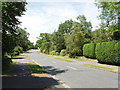
1
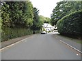
Howards Wood Drive
The southernmost street in Gerrards Cross. Noise from the M40 is clearly audible.
Image: © Des Blenkinsopp
Taken: 30 Oct 2019
0.05 miles
3
Fulmer Drive, Gerrards Cross
There are houses set back among the trees either side of this road in an urban area.
Image: © David Hawgood
Taken: 22 Jun 2005
0.09 miles
4
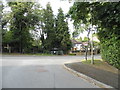
Howards Wood Drive at the junction of High Beeches
Image: © David Howard
Taken: 15 Jun 2017
0.10 miles
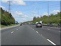
5

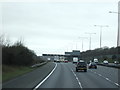
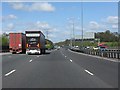
On the M40 heading west, going under power lines
Image: © Rob Purvis
Taken: 14 Aug 2021
0.19 miles
6
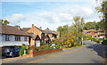
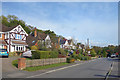
The Uplands, Gerrards Cross
There are no real hills in Gerrards Cross, but the underlying Chilterns make for quite a few ups and downs.
Image: © Des Blenkinsopp
Taken: 30 Oct 2019
0.19 miles
7
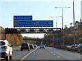
M40 Motorway crossed by power lines near Gerrards Cross
Image: © Peter Whatley
Taken: 12 Apr 2011
0.20 miles
8
M40 Motorway just west of Fulmer Road bridge
Image: © Peter Whatley
Taken: 12 Apr 2011
0.20 miles