IMAGES TAKEN NEAR TO
Dukes Kiln Drive, GERRARDS CROSS, SL9 7HD
Introduction
This page details the photographs taken nearby to Dukes Kiln Drive, SL9 7HD by members of the Geograph project.
The Geograph project started in 2005 with the aim of publishing, organising and preserving representative images for every square kilometre of Great Britain, Ireland and the Isle of Man.

There are currently over 7.5m images from over14,400 individuals and you can help contribute to the project by visiting https://www.geograph.org.uk
Image Map
Images are licensed for reuse under creativecommons.org/licenses/by-sa/2.0
Notes
- Clicking on the map will re-center to the selected point.
- The higher the marker number, the further away the image location is from the centre of the postcode.
Image Listing (9 Images Found)
Images are licensed for reuse under creativecommons.org/licenses/by-sa/2.0
Image
Details
Distance
2
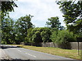
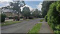
Windsor Road, Gerrards Cross
This is at the southern fringe of the town, looking south with the road about to go down into the Alderbourne valley and under the M40 motorway. There are houses set back among the trees.
Image: © David Hawgood
Taken: 22 Jun 2005
0.16 miles
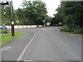
5
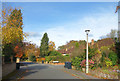
Fulmer Drive - Gerrard's Cross
Large detached houses to the south of the expensive commuter town.
Image: © James Emmans
Taken: 23 Jun 2021
0.19 miles
6
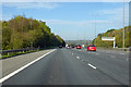
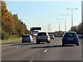
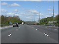
M40 towards Oxford
Between junctions 1a and 2.
Image: © Robin Webster
Taken: 20 Oct 2018
0.22 miles
7
Hedgerley Lane at the junction of Windsor Road
Been there done that http://www.geograph.org.uk/photo/5429690
Image: © David Howard
Taken: 27 Jan 2018
0.23 miles
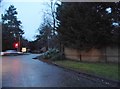
8
Hedgerley Lane at the junction of Windsor Road
Image: © David Howard
Taken: 15 Jun 2017
0.23 miles
9
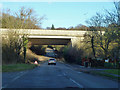
B416 under M40
Windsor Road has 'Flood' signs in place after much recent rain, but the dip here has dried out now.
Image: © Robin Webster
Taken: 19 Jan 2014
0.24 miles