IMAGES TAKEN NEAR TO
Fulmer Road, GERRARDS CROSS, SL9 7EF
Introduction
This page details the photographs taken nearby to Fulmer Road, SL9 7EF by members of the Geograph project.
The Geograph project started in 2005 with the aim of publishing, organising and preserving representative images for every square kilometre of Great Britain, Ireland and the Isle of Man.

There are currently over 7.5m images from over14,400 individuals and you can help contribute to the project by visiting https://www.geograph.org.uk
Image Map
Images are licensed for reuse under creativecommons.org/licenses/by-sa/2.0
Notes
- Clicking on the map will re-center to the selected point.
- The higher the marker number, the further away the image location is from the centre of the postcode.
Image Listing (8 Images Found)
Images are licensed for reuse under creativecommons.org/licenses/by-sa/2.0
Image
Details
Distance
1
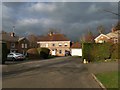
St Huberts Close
Named after a listed hunting lodge nearby, which was built for an aristocrat.
Image: © James Emmans
Taken: 14 Jan 2019
0.11 miles

5
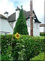
Sunflowers - Gerrards Cross
I didn't think that they opened this early, 1½ sunflowers and a bird-box to the right on the telegraph pole.
Image: © Phillip Perry
Taken: 22 Jun 2008
0.22 miles
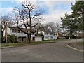
7
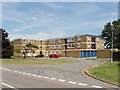
Flats near Gaviots Green, Gerrards Cross
In case other photos of Gerrards Cross seem to be all detached houses round open spaces or surrounded by trees, here are some flats.
Image: © David Hawgood
Taken: 22 Jun 2005
0.23 miles