IMAGES TAKEN NEAR TO
Oxford Road, GERRARDS CROSS, SL9 7AN
Introduction
This page details the photographs taken nearby to Oxford Road, SL9 7AN by members of the Geograph project.
The Geograph project started in 2005 with the aim of publishing, organising and preserving representative images for every square kilometre of Great Britain, Ireland and the Isle of Man.

There are currently over 7.5m images from over14,400 individuals and you can help contribute to the project by visiting https://www.geograph.org.uk
Image Map
Images are licensed for reuse under creativecommons.org/licenses/by-sa/2.0
Notes
- Clicking on the map will re-center to the selected point.
- The higher the marker number, the further away the image location is from the centre of the postcode.
Image Listing (38 Images Found)
Images are licensed for reuse under creativecommons.org/licenses/by-sa/2.0
Image
Details
Distance
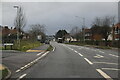

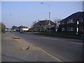
4
Oxford Road Tatling End
At police station exit
Image: © David Howard
Taken: 8 Mar 2011
0.05 miles
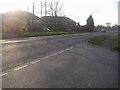
6
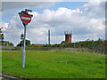
Indications of a fire station
The hose drying and drill tower of Gerrards Cross Fire Station shows over bushes. It apparently doubles as communications tower. The separate communications tower may be run by a different body.
Image: © Robin Webster
Taken: 21 Sep 2014
0.06 miles
7
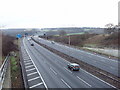
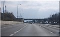
M25 Motorway near Gerrards Cross
Looking north from the A40 on the outskirts of Gerrards Cross
Image: © David Hawgood
Taken: 15 Jan 2006
0.06 miles
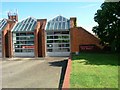
8
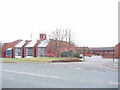
Gerrards Cross fire station
The houses behind are for fire station personnel
Image: © David Hawgood
Taken: 15 Jan 2006
0.06 miles