IMAGES TAKEN NEAR TO
Marsham Lane, GERRARDS CROSS, SL9 7AB
Introduction
This page details the photographs taken nearby to Marsham Lane, SL9 7AB by members of the Geograph project.
The Geograph project started in 2005 with the aim of publishing, organising and preserving representative images for every square kilometre of Great Britain, Ireland and the Isle of Man.

There are currently over 7.5m images from over14,400 individuals and you can help contribute to the project by visiting https://www.geograph.org.uk
Image Map
Images are licensed for reuse under creativecommons.org/licenses/by-sa/2.0
Notes
- Clicking on the map will re-center to the selected point.
- The higher the marker number, the further away the image location is from the centre of the postcode.
Image Listing (17 Images Found)
Images are licensed for reuse under creativecommons.org/licenses/by-sa/2.0
Image
Details
Distance
1
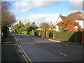
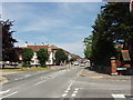
Gerrards Cross: Marsham Way
Marsham Way was one of the earliest roads to be developed in Gerrards Cross, and is shown in more or less its current form on the 1925 edition of the Ordnance Survey large scale mapping. The distant tall narrow green object is a sewage vent pipe.
Image: © Nigel Cox
Taken: 22 Dec 2013
0.09 miles
2
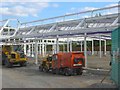
New Supermarket at Gerrards Cross
This is to be a Tesco supermarket which spans the railway cutting and is across the road from the station.
Image: © Jack Hill
Taken: 19 Jul 2005
0.13 miles
3
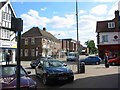
This is Gerrards Cross town centre {to my mind}
The shops had a few customers at 4.15 pm.
Image: © Jack Hill
Taken: 19 Jul 2005
0.13 miles
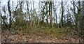
4
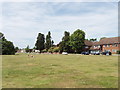
Gerrards Cross Common
This open space is just South of the town centre, taken looking West from East Common.
Image: © David Hawgood
Taken: 22 Jun 2005
0.14 miles
5
Gerrards Cross town centre from the common
This is the view from the common towards the shopping area.
Image: © David Hawgood
Taken: 22 Jun 2005
0.19 miles
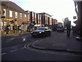
6
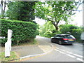
Mill Lane at the junction of Hill Waye
Image: © David Howard
Taken: 11 Jun 2013
0.20 miles
7
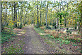
Woodland Path on the Common
Gerrards Cross Common is a pleasant area of woodland surrounded by suburban development. It has a lot of public footpaths through it.
Image: © Des Blenkinsopp
Taken: 30 Oct 2019
0.20 miles
9
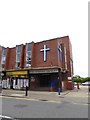
St Andrew's URC, Gerrards Cross: mid August 2016
Image: © Basher Eyre
Taken: 13 Aug 2016
0.22 miles
10
Shops on Packhorse Road, Gerrards Cross
Image: © David Howard
Taken: 8 Mar 2011
0.22 miles