IMAGES TAKEN NEAR TO
Rouse Court, Lower Road, GERRARDS CROSS, SL9 0NJ
Introduction
This page details the photographs taken nearby to Rouse Court, Lower Road, SL9 0NJ by members of the Geograph project.
The Geograph project started in 2005 with the aim of publishing, organising and preserving representative images for every square kilometre of Great Britain, Ireland and the Isle of Man.

There are currently over 7.5m images from over14,400 individuals and you can help contribute to the project by visiting https://www.geograph.org.uk
Image Map
Images are licensed for reuse under creativecommons.org/licenses/by-sa/2.0
Notes
- Clicking on the map will re-center to the selected point.
- The higher the marker number, the further away the image location is from the centre of the postcode.
Image Listing (7 Images Found)
Images are licensed for reuse under creativecommons.org/licenses/by-sa/2.0
Image
Details
Distance
1
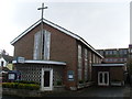
Gerrards Cross Methodist Church
Located at 70 Oakend Way SL9 8BZ, this present Church was officially opened on Wednesday 26th August 1958, although there has been a Church on that site since 1908. It is one of nine Churches in the Amersham Circuit, although it was previously in the Hillingdon Circuit until 31st August 2006 when it transferred into the new Circuit. Services take place every Sunday at 11.00am with activities being held during during the week.
Image: © David Hillas
Taken: 28 Jan 2014
0.18 miles
2
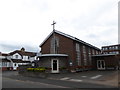
Gerrards Cross Methodist Church: mid August 2016
Image: © Basher Eyre
Taken: 13 Aug 2016
0.18 miles
3
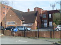
Gerrards Cross Telephone Exchange
Situated in Station Road, this TE combines the old, which dates from 1935, and the new and has the code THGX. It provides telephone and broadband services to 6,640 residential and 455 non-residential premises in Gerrards Cross plus Chalfont St. Peter nearby. The numbering ranges of this TE are (01753) 88xxxx, 89xxxx, the (01753) referring to the Slough group of eight TEs and its postcode is SL9 8ES.
Image: © David Hillas
Taken: 21 Feb 2009
0.22 miles
7
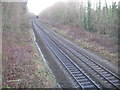
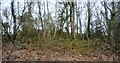
Gerrards Cross: Chiltern Railways main line
The line was a very late addition to the national railway network, only being completed in 1906 as a joint venture by the Great Western and Great Central Railways. This is the view from the side of the Mill Lane bridge over it, looking towards Gerrards Cross station.
Image: © Nigel Cox
Taken: 22 Dec 2013
0.25 miles