IMAGES TAKEN NEAR TO
Sycamore Close, BOURNE END, SL8 5UT
Introduction
This page details the photographs taken nearby to Sycamore Close, SL8 5UT by members of the Geograph project.
The Geograph project started in 2005 with the aim of publishing, organising and preserving representative images for every square kilometre of Great Britain, Ireland and the Isle of Man.

There are currently over 7.5m images from over14,400 individuals and you can help contribute to the project by visiting https://www.geograph.org.uk
Image Map
Images are licensed for reuse under creativecommons.org/licenses/by-sa/2.0
Notes
- Clicking on the map will re-center to the selected point.
- The higher the marker number, the further away the image location is from the centre of the postcode.
Image Listing (27 Images Found)
Images are licensed for reuse under creativecommons.org/licenses/by-sa/2.0
Image
Details
Distance
1
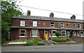
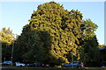
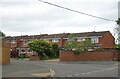
Willows Road, Wooburn Green
From the A4094
Image: © David Howard
Taken: 27 Mar 2019
0.04 miles
3
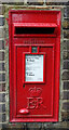
Elizabeth II postbox on Cores End Road
Postbox No. SL8 46.
Image: © JThomas
Taken: 26 May 2022
0.07 miles
4
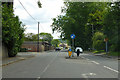
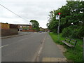
A4094 Cores End Road, Bourne End
Towards Beaconsfield.
Image: © Robin Webster
Taken: 9 Jun 2019
0.07 miles
7
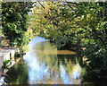
River Wye at Bourne End
The Buckinghamshire Wye is a chalk stream which, upstream from High Wycombe, has a Bourne section where flow is intermittent depending on groundwater levels in the Chiltern aquifer.
The Wye joins the Thames a short distance downstream from here, hence Bourne End.
Image: © Des Blenkinsopp
Taken: 8 Nov 2018
0.09 miles
10
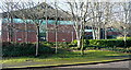
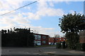
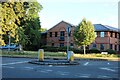
Business at Bourne End
One of the modern office premises to the east of the town.
Image: © Graham Horn
Taken: 5 Dec 2010
0.14 miles