IMAGES TAKEN NEAR TO
Cressington Place, BOURNE END, SL8 5SN
Introduction
This page details the photographs taken nearby to Cressington Place, SL8 5SN by members of the Geograph project.
The Geograph project started in 2005 with the aim of publishing, organising and preserving representative images for every square kilometre of Great Britain, Ireland and the Isle of Man.

There are currently over 7.5m images from over14,400 individuals and you can help contribute to the project by visiting https://www.geograph.org.uk
Image Map
Images are licensed for reuse under creativecommons.org/licenses/by-sa/2.0
Notes
- Clicking on the map will re-center to the selected point.
- The higher the marker number, the further away the image location is from the centre of the postcode.
Image Listing (19 Images Found)
Images are licensed for reuse under creativecommons.org/licenses/by-sa/2.0
Image
Details
Distance
4
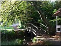
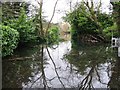
Footbridge on the Abbotsbrook Estate
Image: © Malcolm Cartledge
Taken: 29 Oct 2005
0.11 miles
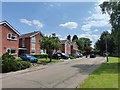
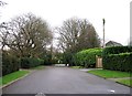
6
The Avenue - Well End
Private estate with large detached houses some old and some recently built.
Image: © James Emmans
Taken: 26 Jun 2020
0.15 miles
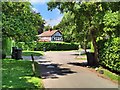
8
Wendover Road - Well End
Modern detached houses on bin day.
Image: © James Emmans
Taken: 26 Jun 2020
0.18 miles