IMAGES TAKEN NEAR TO
Bramley Gardens, BOURNE END, SL8 5FF
Introduction
This page details the photographs taken nearby to Bramley Gardens, SL8 5FF by members of the Geograph project.
The Geograph project started in 2005 with the aim of publishing, organising and preserving representative images for every square kilometre of Great Britain, Ireland and the Isle of Man.

There are currently over 7.5m images from over14,400 individuals and you can help contribute to the project by visiting https://www.geograph.org.uk
Image Map
Images are licensed for reuse under creativecommons.org/licenses/by-sa/2.0
Notes
- Clicking on the map will re-center to the selected point.
- The higher the marker number, the further away the image location is from the centre of the postcode.
Image Listing (122 Images Found)
Images are licensed for reuse under creativecommons.org/licenses/by-sa/2.0
Image
Details
Distance

5
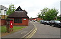
Boston Drive, Bourne End
Showing position of Postbox No. SL8 224.
See Image] for postbox.
Image: © JThomas
Taken: 26 May 2022
0.05 miles
8
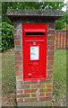
Elizabeth II postbox on Boston Drive, Bourne End
Postbox No. SL8 224.
See Image] for context.
Image: © JThomas
Taken: 26 May 2022
0.05 miles

10
Beyond Bourne End Station
Just over the road from where the tracks stop at Bourne End station, the line of the old rail route to High Wycombe is immediately lost under the road into a business park.
Image: © Des Blenkinsopp
Taken: 8 Nov 2018
0.05 miles