IMAGES TAKEN NEAR TO
Riversdale, BOURNE END, SL8 5EB
Introduction
This page details the photographs taken nearby to Riversdale, SL8 5EB by members of the Geograph project.
The Geograph project started in 2005 with the aim of publishing, organising and preserving representative images for every square kilometre of Great Britain, Ireland and the Isle of Man.

There are currently over 7.5m images from over14,400 individuals and you can help contribute to the project by visiting https://www.geograph.org.uk
Image Map
Images are licensed for reuse under creativecommons.org/licenses/by-sa/2.0
Notes
- Clicking on the map will re-center to the selected point.
- The higher the marker number, the further away the image location is from the centre of the postcode.
Image Listing (50 Images Found)
Images are licensed for reuse under creativecommons.org/licenses/by-sa/2.0
Image
Details
Distance

4
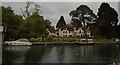
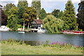
Orchard Dene Cottages
B&B accommodation by the River Thames
Image: © Paul Gillett
Taken: 4 May 2017
0.10 miles
5
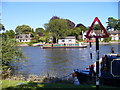
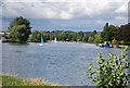
The Thames from Cock Marsh
Looking east to the Bourne End bank with its expensive riverside houses. A narrowboat is heading downstream.
Image: © Colin Smith
Taken: 4 Aug 2007
0.11 miles
7
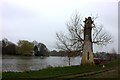
Orange Way after Wiltshire (420)
Here's a redundant bridge no longer used by the footpath.
Image: © Shazz
Taken: 31 Aug 2013
0.12 miles
8
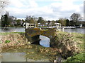
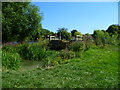
Cracked bridge
A very small bridge by the River Thames which is no longer in use presumably because of the large cracks in it!
Image: © don cload
Taken: 6 Mar 2012
0.12 miles