IMAGES TAKEN NEAR TO
Ragmans Lane, MARLOW, SL7 3SL
Introduction
This page details the photographs taken nearby to Ragmans Lane, SL7 3SL by members of the Geograph project.
The Geograph project started in 2005 with the aim of publishing, organising and preserving representative images for every square kilometre of Great Britain, Ireland and the Isle of Man.

There are currently over 7.5m images from over14,400 individuals and you can help contribute to the project by visiting https://www.geograph.org.uk
Image Map
Images are licensed for reuse under creativecommons.org/licenses/by-sa/2.0
Notes
- Clicking on the map will re-center to the selected point.
- The higher the marker number, the further away the image location is from the centre of the postcode.
Image Listing (14 Images Found)
Images are licensed for reuse under creativecommons.org/licenses/by-sa/2.0
Image
Details
Distance
1
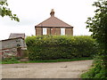
Old House Farm, Handy Cross
The farmhouse has hedges close around it. Outbuildings on the left are in the farmyard which has several open barns. The house is also seen across the fields in Image
Image: © David Hawgood
Taken: 29 Aug 2008
0.01 miles
2
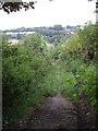
Footpath from Old House Farm to High Wycombe
Starting near Handy Cross this path goes under the M40.
Image: © David Hawgood
Taken: 29 Aug 2008
0.03 miles
3
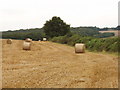
Stubble and straw bales, Handy Cross
By Old House Farm
Image: © David Hawgood
Taken: 29 Aug 2008
0.06 miles
4
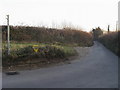
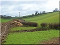
Ragmans Lane
Ragmans Lane by bridleway at Old House Farm
Image: © Shaun Ferguson
Taken: 29 Dec 2008
0.09 miles
5
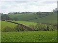
Farmland, Marlow
Cereal fields in a couple of dry valleys. Buildings at Handy Cross are just visible on the skyline.
Image: © Andrew Smith
Taken: 29 Mar 2008
0.10 miles
6
Farmland, Marlow
Old House Farm is on the skyline.
Image: © Andrew Smith
Taken: 29 Mar 2008
0.13 miles
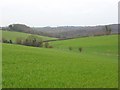
7

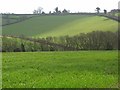
Farmland, Great Marlow
Arable land in the valley south-west of Handy Cross.
Image: © Andrew Smith
Taken: 13 Nov 2023
0.14 miles
8
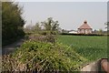
Handy Cross
Looking north towards Old House Farm. This square is mainly farmland with some woods to the east.
Image: © Brendan and Ruth McCartney
Taken: 21 Apr 2005
0.19 miles
9
Farmland, Marlow
A dry valley at Hill Green with a private track.
Image: © Andrew Smith
Taken: 29 Mar 2008
0.19 miles
10
Farmland, Marlow
Cereal fields in the valley above Marlow Bottom. Looking towards Hillgreen and Hollyhill Woods from a footpath beside the M40.
Image: © Andrew Smith
Taken: 15 Mar 2008
0.20 miles