IMAGES TAKEN NEAR TO
Fern Lane, MARLOW, SL7 3SF
Introduction
This page details the photographs taken nearby to Fern Lane, SL7 3SF by members of the Geograph project.
The Geograph project started in 2005 with the aim of publishing, organising and preserving representative images for every square kilometre of Great Britain, Ireland and the Isle of Man.

There are currently over 7.5m images from over14,400 individuals and you can help contribute to the project by visiting https://www.geograph.org.uk
Image Map
Images are licensed for reuse under creativecommons.org/licenses/by-sa/2.0
Notes
- Clicking on the map will re-center to the selected point.
- The higher the marker number, the further away the image location is from the centre of the postcode.
Image Listing (8 Images Found)
Images are licensed for reuse under creativecommons.org/licenses/by-sa/2.0
Image
Details
Distance
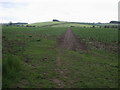
3
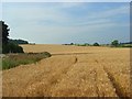
Farmland, Little Marlow
Fields climbing into the Chilterns from the northern end of the hamlet of Fern.
Image: © Andrew Smith
Taken: 24 Jul 2008
0.19 miles
7
Bridleway to Sheepridge Lane
From Fern Lane the bridleway to Sheepridge Lane that then carries straight on towards Flackwell Heath
Image: © Shaun Ferguson
Taken: 16 May 2009
0.23 miles
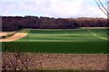
8
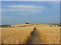
Farmland, Little Marlow
The bridleway crossing fields as it leaves Fern. A footpath can be seen climbing the hillside on a similar line.
Image: © Andrew Smith
Taken: 24 Jul 2008
0.25 miles