IMAGES TAKEN NEAR TO
Church Road, MARLOW, SL7 3RT
Introduction
This page details the photographs taken nearby to Church Road, SL7 3RT by members of the Geograph project.
The Geograph project started in 2005 with the aim of publishing, organising and preserving representative images for every square kilometre of Great Britain, Ireland and the Isle of Man.

There are currently over 7.5m images from over14,400 individuals and you can help contribute to the project by visiting https://www.geograph.org.uk
Image Map
Images are licensed for reuse under creativecommons.org/licenses/by-sa/2.0
Notes
- Clicking on the map will re-center to the selected point.
- The higher the marker number, the further away the image location is from the centre of the postcode.
Image Listing (40 Images Found)
Images are licensed for reuse under creativecommons.org/licenses/by-sa/2.0
Image
Details
Distance
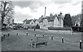
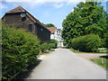
1
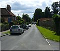
Church Road, Little Marlow
The white house in the distance is Manor Farm and behind the wall on the right is the Manor House.
Image: © Sean Davis
Taken: 28 Jul 2007
0.03 miles
2
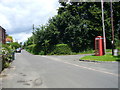
The Old Red Telephone Box at Little Marlow
This is at the junction of Church Road and School Lane. It is on the route of the London Green Belt Way.
Image: © Sean Davis
Taken: 28 Jul 2007
0.04 miles
3
Pound Lane, Little Marlow
The building in the distance is The Queen's Head. Just past the pub the lane narrows to footpath and leads to Marlow.
Image: © Sean Davis
Taken: 28 Jul 2007
0.05 miles
4
Church Road, Little Marlow
At the southern end of the village by the church and manor house.
Image: © Des Blenkinsopp
Taken: 20 Feb 2017
0.05 miles
5
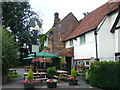
Queen's Head, Little Marlow
The 16th century Queen's Head in Pound Lane, Little Marlow. It was one of Morse's favourite watering holes the TV series Inspector Morse, and often appeared in Midsomer Murders. A public footpath from here leads all the way to Marlow.
Image: © Sean Davis
Taken: 28 Jul 2007
0.06 miles
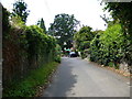
6
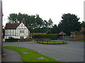
The Small Green on Church Road, Little Marlow
This is where the road widens, next to the lychgate, war memorial and Manor Farm. It is on the route of the London Green Belt Way.
Image: © Sean Davis
Taken: 28 Jul 2007
0.06 miles
8
North into Little Marlow
Going north along The Moor towards Little Marlow. The white building is the Manor Farmhouse, a late 17 century, grade 2 listed building - see https://historicengland.org.uk/listing/the-list/list-entry/1332122
This is also on the route of the London Green Belt Way.
Image: © Sean Davis
Taken: 21 May 2011
0.07 miles
9

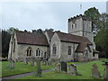
Little Marlow church
Dedicated to St. John the Baptist. Most of the building dates from the 14th and 15th centuries. Mel Brown, Scary Spice from the girl group the Spice Girls, married dancer Jimmy Gulzar here in 1998. I don't know if they returned before their marriage broke up the following year.
Image: © Graham Horn
Taken: 15 Aug 2010
0.08 miles