IMAGES TAKEN NEAR TO
Winchbottom Lane, MARLOW, SL7 3RJ
Introduction
This page details the photographs taken nearby to Winchbottom Lane, SL7 3RJ by members of the Geograph project.
The Geograph project started in 2005 with the aim of publishing, organising and preserving representative images for every square kilometre of Great Britain, Ireland and the Isle of Man.

There are currently over 7.5m images from over14,400 individuals and you can help contribute to the project by visiting https://www.geograph.org.uk
Image Map
Images are licensed for reuse under creativecommons.org/licenses/by-sa/2.0
Notes
- Clicking on the map will re-center to the selected point.
- The higher the marker number, the further away the image location is from the centre of the postcode.
Image Listing (9 Images Found)
Images are licensed for reuse under creativecommons.org/licenses/by-sa/2.0
Image
Details
Distance
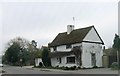
1
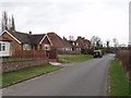
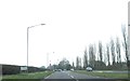
Houses in Winchbottom Lane, Little Marlow
In the lower stretch of the lane as it joins the A4155.
Image: © David Hawgood
Taken: 6 Mar 2008
0.05 miles
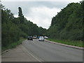
5
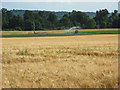
Farmland, Little Marlow
Barley beside the footpath above Wilton Farm. Beyond a green crop is being irrigated. The line of trees is on the A4155.
Image: © Andrew Smith
Taken: 25 Jul 2008
0.19 miles
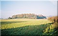
6
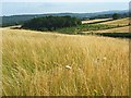
Countryside, Little Marlow
Looking towards a copse just beyond Winchbottom Lane. Beyond are the largely wooded hills beyond the Thames around Bisham.
Image: © Andrew Smith
Taken: 25 Jul 2008
0.19 miles
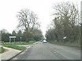
9
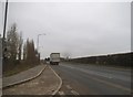
Approaching The Kings Head, Little Marlow
Image: © Alex McGregor
Taken: 12 Mar 2014
0.25 miles