IMAGES TAKEN NEAR TO
Monkton Lane, MARLOW, SL7 3RF
Introduction
This page details the photographs taken nearby to Monkton Lane, SL7 3RF by members of the Geograph project.
The Geograph project started in 2005 with the aim of publishing, organising and preserving representative images for every square kilometre of Great Britain, Ireland and the Isle of Man.

There are currently over 7.5m images from over14,400 individuals and you can help contribute to the project by visiting https://www.geograph.org.uk
Image Map
Images are licensed for reuse under creativecommons.org/licenses/by-sa/2.0
Notes
- Clicking on the map will re-center to the selected point.
- The higher the marker number, the further away the image location is from the centre of the postcode.
Image Listing (6 Images Found)
Images are licensed for reuse under creativecommons.org/licenses/by-sa/2.0
Image
Details
Distance
6
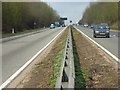
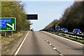
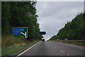
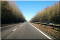
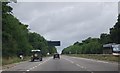
The A404, Little Marlow
Viewed from where it is crossed by a public footpath below Monkton Farm. This is part of a long, gradual climb out of the Thames valley whereby the road gains about 100 metres in altitude.
Image: © Andrew Smith
Taken: 15 Mar 2008
0.19 miles