IMAGES TAKEN NEAR TO
Ragmans Close, MARLOW, SL7 3QW
Introduction
This page details the photographs taken nearby to Ragmans Close, SL7 3QW by members of the Geograph project.
The Geograph project started in 2005 with the aim of publishing, organising and preserving representative images for every square kilometre of Great Britain, Ireland and the Isle of Man.

There are currently over 7.5m images from over14,400 individuals and you can help contribute to the project by visiting https://www.geograph.org.uk
Image Map
Images are licensed for reuse under creativecommons.org/licenses/by-sa/2.0
Notes
- Clicking on the map will re-center to the selected point.
- The higher the marker number, the further away the image location is from the centre of the postcode.
Image Listing (9 Images Found)
Images are licensed for reuse under creativecommons.org/licenses/by-sa/2.0
Image
Details
Distance
1
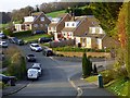
Andrews Way, Marlow Bottom
Houses at the northern end of a hilly village seen from the junction with High View Close.
Image: © Andrew Smith
Taken: 31 Mar 2019
0.03 miles
2
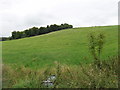
Pasture by Marlow Bottom
View from the corner of Marlow Bottom and ragmans lane
Image: © David Hawgood
Taken: 29 Aug 2008
0.11 miles
3

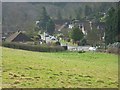
Houses in Marlow Bottom by Ragmans Lane
View from end of bridleway to Hill Green. Ragmans Lane goes up on the left.
Image: © David Hawgood
Taken: 29 Aug 2008
0.12 miles
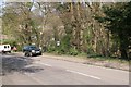
4
Marlow Bottom
The southern end of the village. Marlow Bottom is also the name of the road.
Image: © Andrew Smith
Taken: 29 Mar 2008
0.14 miles
5
Marlow Bottom
Overlooking the housing estate on the northern outskirts of the town from the minor road in the north of the square.
Image: © Brendan and Ruth McCartney
Taken: 21 Apr 2005
0.14 miles
6
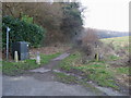
Footpath off Ragmans Lane
Footpath by High Heavens Wood off Ragmans Lane
Image: © Shaun Ferguson
Taken: 29 Dec 2008
0.16 miles
7
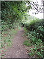
Bridleway near Marlow Bottom
This bridleway goes to Handy Cross.
Image: © David Hawgood
Taken: 29 Aug 2008
0.20 miles
8
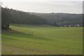
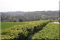
Field down to Marlow Bottom
New housing has been spreading up the valley bottom.
Image: © Bill Boaden
Taken: 27 Jan 2024
0.24 miles
9
Marlow Bottom
Munces Wood - a tiny area of woodland in a busy residential area.
Image: © Brendan and Ruth McCartney
Taken: 21 Apr 2004
0.24 miles