IMAGES TAKEN NEAR TO
Claymoor Park, MARLOW, SL7 3DL
Introduction
This page details the photographs taken nearby to Claymoor Park, SL7 3DL by members of the Geograph project.
The Geograph project started in 2005 with the aim of publishing, organising and preserving representative images for every square kilometre of Great Britain, Ireland and the Isle of Man.

There are currently over 7.5m images from over14,400 individuals and you can help contribute to the project by visiting https://www.geograph.org.uk
Image Map
Images are licensed for reuse under creativecommons.org/licenses/by-sa/2.0
Notes
- Clicking on the map will re-center to the selected point.
- The higher the marker number, the further away the image location is from the centre of the postcode.
Image Listing (15 Images Found)
Images are licensed for reuse under creativecommons.org/licenses/by-sa/2.0
Image
Details
Distance
1
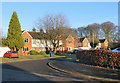
Claymoor Park
Residential street off Clay Lane in Clayhill.
Bit of a clay thing going on here.
Image: © Des Blenkinsopp
Taken: 17 Jan 2017
0.03 miles
2
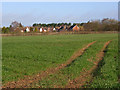
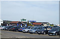
Farmland and houses, Booker
Houses to the south of Wycombe Air Park viewed from the footpath to the south.
Image: © Andrew Smith
Taken: 29 Mar 2008
0.04 miles
6
A New Hedge
A new bit of planting beside the entrance to a recycling centre.
Image: © Des Blenkinsopp
Taken: 17 Jan 2017
0.15 miles
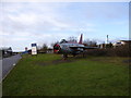
7
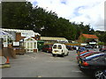
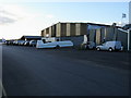
Wycombe Air Park
In the foreground is the main car park for the airfield.The building with the green windows is the Tower and the building to the right of the Tower with the blue sign is the British Airways Flying Club. http://www.bafc.co.uk/
Image: © terry joyce
Taken: 26 Apr 2008
0.16 miles
8
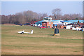
Towards the Control Tower, Wycombe Air Park
The airfield here opened in 1941 and was called RAF Booker, and remained a military airfield up to 1965.
In civil use since then, the airfield hosts a flying club and provides training and services.
Image: © Des Blenkinsopp
Taken: 18 Jan 2017
0.16 miles
9
Wycombe Air Park
Wycombe Air Park at Booker
Image: © Shaun Ferguson
Taken: 7 Mar 2008
0.17 miles
10
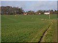
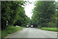
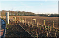
Farmland, Marlow
Looking west along a bridleway approaching Reading Shaw and adjacent houses.
Image: © Andrew Smith
Taken: 29 Mar 2008
0.19 miles